Calexico geodata
Calexico (California) is a populated place; located in United States in America/Los_Angeles (GMT-7) time zone. With population of 40,053 people, there are 1207 cities with bigger population in this country. Compared to other cities in United States, 86.5% of cities are located further ↑North; 89% of cities are located further →East and 99.8% of cities have higher elevation than Calexico. Note1


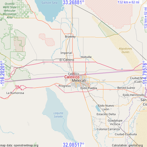
Calexico GPS coordinates[2]
32° 40' 44.22" North, 115° 29' 55.968" West
| Map corner | latitude | longitude |
|---|---|---|
| Upper-left | 33.26881°, | -116.20201° |
| Center: | 32.67895°, | -115.49888° |
| Lower-right: | 32.08517°, | -114.79576° |
| Map W x H: | 131.6×131.6 km | = 81.8×81.8mi |
| max Lat: | 71.29058° ⇑86.5% North |
| Calexico: | 32.67895° |
| min Lat: | ⇓13.5% South 19.06759° |
| min Long | Calexico | max Long |
| -171.73463° | -115.49888° | -66.98998° |
| W 11%⇐ | ⇒89% E |
Elevation
Elevation of Calexico is -2 m = -7 ft, and this is 296.8 m = 974 ft below average elevation for this country.
| Max E: |
3189 m = 10463 ft | 99.8% |
| Avg. | 294.8 m = 967 ft | |
| Calexico | -2 m = -7 ft | |
Min E: |
-60 m = -197 ft | 0.2% |
See also: Calexico elevation on elevation.city.
Geographical zone
Calexico is located in North temperate zone (between Tropic of Cancer and the Arctic Circle). Distance of this Northern Tropic circle is 1027.6 km =638.5 mi to South.| Distance of | km | miles | from Calexico |
|---|---|---|---|
| North Pole | 6373.5 | 3960.3 | to North |
| Arctic Circle | 3767.6 | 2341.1 | to North |
| Tropic Cancer | 1027.6 | 638.5 | to South |
| Equator | 3633.6 | 2257.8 | to South |


Nearby cities:
15 places around Calexico: (largest is in red/bold)
• Avenue B and C
78.6 km =48.8 mi,  86°
86°
• Brawley
33.5 km =20.8 mi,  354°
354°
• Calipatria
49.7 km =30.9 mi,  358°
358°
• Donovan Estates
76.9 km =47.8 mi, 87°
• El Centro
13.9 km =8.6 mi,  334°
334°
• Gadsden
68.3 km =42.4 mi,  101°
101°
• Heber
6.5 km =4 mi, 333°
• Holtville
18.4 km =11.4 mi,  37°
37°
• Imperial
19.9 km =12.4 mi,  340°
340°
• Jacumba Hot Springs
65 km =40.4 mi,  263°
263°
• Niland
62.4 km =38.8 mi, 358°
• San Luis
70.5 km =43.8 mi,  107°
107°
• Seeley
22 km =13.7 mi,  305°
305°
• Somerton
74.5 km =46.3 mi, 97°
• Westmorland
41.5 km =25.8 mi, 343°
Sources, notices
• [Note1] Compared only with cities in United States existing in our database
• [Src1] Map data: © OpenStreetMap contributors (CC-BY-SA)
• [Src2] Other city data from geonames.org with taken over terms of usage.
• [Src3] Geographical zone / Annual Mean Temperature by Robert A. Rohde @ Wikipedia
