Holtville geodata
Holtville (California) is a populated place; located in United States in America/Los_Angeles (GMT-7) time zone. With population of 6,404 people, there are 6169 cities with bigger population in this country. Compared to other cities in United States, 85.9% of cities are located further ↑North; 89% of cities are located further →East and 99.8% of cities have higher elevation than Holtville. Note1


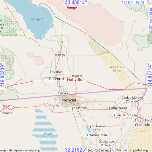
Holtville GPS coordinates[2]
32° 48' 40.176" North, 115° 22' 48.936" West
| Map corner | latitude | longitude |
|---|---|---|
| Upper-left | 33.40014°, | -116.08339° |
| Center: | 32.81116°, | -115.38026° |
| Lower-right: | 32.21825°, | -114.67714° |
| Map W x H: | 131.4×131.4 km | = 81.6×81.6mi |
| max Lat: | 71.29058° ⇑85.9% North |
| Holtville: | 32.81116° |
| min Lat: | ⇓14.1% South 19.06759° |
| min Long | Holtville | max Long |
| -171.73463° | -115.38026° | -66.98998° |
| W 11%⇐ | ⇒89% E |
Elevation
Elevation of Holtville is -4 m = -13 ft, and this is 298.8 m = 980 ft below average elevation for this country.
| Max E: |
3189 m = 10463 ft | 99.8% |
| Avg. | 294.8 m = 967 ft | |
| Holtville | -4 m = -13 ft | |
Min E: |
-60 m = -197 ft | 0.2% |
See also: United States elevation on elevation.city.
Geographical zone
Holtville is located in North temperate zone (between Tropic of Cancer and the Arctic Circle). Distance of this Northern Tropic circle is 1042.3 km =647.7 mi to South.| Distance of | km | miles | from Holtville |
|---|---|---|---|
| North Pole | 6358.8 | 3951.2 | to North |
| Arctic Circle | 3752.9 | 2331.9 | to North |
| Tropic Cancer | 1042.3 | 647.7 | to South |
| Equator | 3648.3 | 2266.9 | to South |


Nearby cities:
15 places around Holtville: (largest is in red/bold)
• Avenue B and C
68.1 km =42.3 mi,  98°
98°
• Brawley
23.3 km =14.5 mi,  323°
323°
• Calexico
18.4 km =11.4 mi,  217°
217°
• Calipatria
37.1 km =23.1 mi,  340°
340°
• Donovan Estates
66.6 km =41.4 mi, 99°
• El Centro
17.2 km =10.7 mi,  262°
262°
• Gadsden
62.6 km =38.9 mi,  117°
117°
• Heber
16.6 km =10.3 mi,  237°
237°
• Imperial
18.1 km =11.2 mi,  282°
282°
• Niland
49.4 km =30.7 mi, 344°
• San Luis
66.6 km =41.4 mi, 122°
• Seeley
29.1 km =18.1 mi,  266°
266°
• Somerton
67.1 km =41.7 mi,  110°
110°
• Westmorland
33.7 km =20.9 mi, 318°
• Yuma
71.3 km =44.3 mi, 97°
Sources, notices
• [Note1] Compared only with cities in United States existing in our database
• [Src1] Map data: © OpenStreetMap contributors (CC-BY-SA)
• [Src2] Other city data from geonames.org with taken over terms of usage.
• [Src3] Geographical zone / Annual Mean Temperature by Robert A. Rohde @ Wikipedia
