El Centro geodata
El Centro (California) is a seat of a second-order administrative division; located in United States in America/Los_Angeles (GMT-7) time zone. With population of 43,956 people, there are 1085 cities with bigger population in this country. Compared to other cities in United States, 86% of cities are located further ↑North; 89% of cities are located further →East and 99.9% of cities have higher elevation than El Centro. Note1


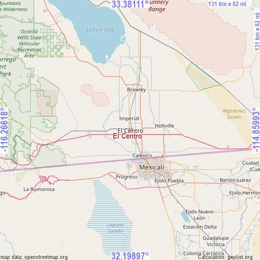
El Centro GPS coordinates[2]
32° 47' 31.2" North, 115° 33' 46.98" West
| Map corner | latitude | longitude |
|---|---|---|
| Upper-left | 33.38111°, | -116.26618° |
| Center: | 32.792°, | -115.56305° |
| Lower-right: | 32.19897°, | -114.85993° |
| Map W x H: | 131.4×131.4 km | = 81.6×81.6mi |
| max Lat: | 71.29058° ⇑86% North |
| El Centro: | 32.792° |
| min Lat: | ⇓14% South 19.06759° |
| min Long | El Centro | max Long |
| -171.73463° | -115.56305° | -66.98998° |
| W 11%⇐ | ⇒89% E |
Elevation
Elevation of El Centro is -14 m = -46 ft, and this is 308.8 m = 1013 ft below average elevation for this country.
| Max E: |
3189 m = 10463 ft | 99.9% |
| Avg. | 294.8 m = 967 ft | |
| El Centro | -14 m = -46 ft | |
Min E: |
-60 m = -197 ft | 0.1% |
See also: El Centro elevation on elevation.city.
Geographical zone
El Centro is located in North temperate zone (between Tropic of Cancer and the Arctic Circle). Distance of this Northern Tropic circle is 1040.2 km =646.4 mi to South.| Distance of | km | miles | from El Centro |
|---|---|---|---|
| North Pole | 6360.9 | 3952.5 | to North |
| Arctic Circle | 3755 | 2333.2 | to North |
| Tropic Cancer | 1040.2 | 646.4 | to South |
| Equator | 3646.1 | 2265.6 | to South |


Nearby cities:
15 places around El Centro: (largest is in red/bold)
• Brawley
21 km =13 mi,  8°
8°
• Calexico
13.9 km =8.6 mi,  154°
154°
• Calipatria
37.4 km =23.2 mi, 7°
• Desert Shores
81.3 km =50.5 mi,  326°
326°
• Gadsden
77.5 km =48.2 mi,  109°
109°
• Heber
7.5 km =4.7 mi,  155°
155°
• Holtville
17.2 km =10.7 mi,  82°
82°
• Imperial
6.2 km =3.9 mi,  354°
354°
• Jacumba Hot Springs
61.8 km =38.4 mi,  251°
251°
• Niland
50 km =31.1 mi,  4°
4°
• Salton City
67.2 km =41.8 mi, 326°
• San Luis
80.6 km =50.1 mi, 114°
• Seeley
12 km =7.5 mi,  270°
270°
• Somerton
82.8 km =51.4 mi, 105°
• Westmorland
27.8 km =17.3 mi, 348°
Sources, notices
• [Note1] Compared only with cities in United States existing in our database
• [Src1] Map data: © OpenStreetMap contributors (CC-BY-SA)
• [Src2] Other city data from geonames.org with taken over terms of usage.
• [Src3] Geographical zone / Annual Mean Temperature by Robert A. Rohde @ Wikipedia
