Imperial geodata
Imperial (California) is a populated place; located in United States in America/Los_Angeles (GMT-7) time zone. With population of 17,095 people, there are 2890 cities with bigger population in this country. Compared to other cities in United States, 85.7% of cities are located further ↑North; 89% of cities are located further →East and 99.9% of cities have higher elevation than Imperial. Note1


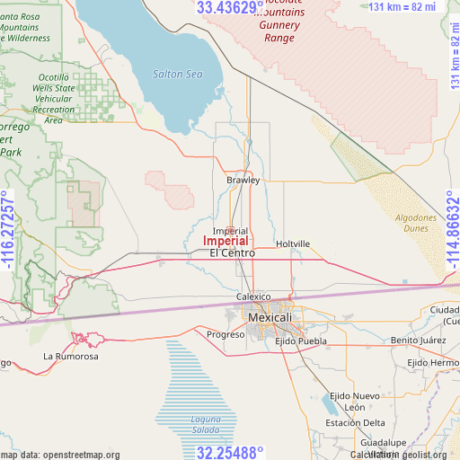
Imperial GPS coordinates[2]
32° 50' 51.18" North, 115° 34' 9.984" West
| Map corner | latitude | longitude |
|---|---|---|
| Upper-left | 33.43629°, | -116.27257° |
| Center: | 32.84755°, | -115.56944° |
| Lower-right: | 32.25488°, | -114.86632° |
| Map W x H: | 131.4×131.4 km | = 81.6×81.6mi |
| max Lat: | 71.29058° ⇑85.7% North |
| Imperial: | 32.84755° |
| min Lat: | ⇓14.3% South 19.06759° |
| min Long | Imperial | max Long |
| -171.73463° | -115.56944° | -66.98998° |
| W 11%⇐ | ⇒89% E |
Elevation
Elevation of Imperial is -19 m = -62 ft, and this is 313.8 m = 1030 ft below average elevation for this country.
| Max E: |
3189 m = 10463 ft | 99.9% |
| Avg. | 294.8 m = 967 ft | |
| Imperial | -19 m = -62 ft | |
Min E: |
-60 m = -197 ft | 0.1% |
See also: United States elevation on elevation.city.
Geographical zone
Imperial is located in North temperate zone (between Tropic of Cancer and the Arctic Circle). Distance of this Northern Tropic circle is 1046.4 km =650.2 mi to South.| Distance of | km | miles | from Imperial |
|---|---|---|---|
| North Pole | 6354.8 | 3948.7 | to North |
| Arctic Circle | 3748.9 | 2329.5 | to North |
| Tropic Cancer | 1046.4 | 650.2 | to South |
| Equator | 3652.3 | 2269.4 | to South |


Nearby cities:
15 places around Imperial: (largest is in red/bold)
• Brawley
15 km =9.3 mi,  14°
14°
• Calexico
19.9 km =12.4 mi,  160°
160°
• Calipatria
31.3 km =19.4 mi, 9°
• Desert Shores
75.8 km =47.1 mi,  324°
324°
• El Centro
6.2 km =3.9 mi,  174°
174°
• Gadsden
80.3 km =49.9 mi,  113°
113°
• Heber
13.5 km =8.4 mi, 164°
• Holtville
18.1 km =11.2 mi,  102°
102°
• Jacumba Hot Springs
63.4 km =39.4 mi,  246°
246°
• Niland
43.9 km =27.3 mi, 6°
• Oasis
84.6 km =52.6 mi, 324°
• Salton City
61.8 km =38.4 mi, 324°
• San Luis
83.9 km =52.1 mi,  118°
118°
• Seeley
12.9 km =8 mi,  241°
241°
• Westmorland
21.6 km =13.4 mi,  347°
347°
Sources, notices
• [Note1] Compared only with cities in United States existing in our database
• [Src1] Map data: © OpenStreetMap contributors (CC-BY-SA)
• [Src2] Other city data from geonames.org with taken over terms of usage.
• [Src3] Geographical zone / Annual Mean Temperature by Robert A. Rohde @ Wikipedia
