Meadview geodata
Meadview (Arizona) is a populated place; located in United States in America/Phoenix (GMT-7) time zone. With population of 1,224 people, there are 14984 cities with bigger population in this country. Compared to other cities in United States, 70.4% of cities are located further ↑North; 88.5% of cities are located further →East and 92.9% of cities have lower elevation than Meadview. Note1


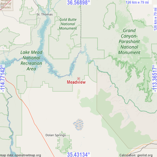
Meadview GPS coordinates[2]
36° 0' 7.956" North, 114° 4' 5.844" West
| Map corner | latitude | longitude |
|---|---|---|
| Upper-left | 36.56898°, | -114.77142° |
| Center: | 36.00221°, | -114.06829° |
| Lower-right: | 35.43134°, | -113.36517° |
| Map W x H: | 126.5×126.5 km | = 78.6×78.6mi |
| max Lat: | 71.29058° ⇑70.4% North |
| Meadview: | 36.00221° |
| min Lat: | ⇓29.6% South 19.06759° |
| min Long | Meadview | max Long |
| -171.73463° | -114.06829° | -66.98998° |
| W 11.5%⇐ | ⇒88.5% E |
Elevation
Elevation of Meadview is 913 m = 2995 ft, and this is 618.2 m = 2028 ft above average elevation for this country.
| Max E: |
3189 m = 10463 ft | 7.1% |
| Meadview | 913 m 2995 ft | |
| Avg. | 294.8 m = 967 ft | |
Min E: |
-60 m = -197 ft | 92.9% |
See also: United States elevation on elevation.city.
Geographical zone
Meadview is located in North temperate zone (between Tropic of Cancer and the Arctic Circle). Distance of this Northern Tropic circle is 1397.2 km =868.2 mi to South.| Distance of | km | miles | from Meadview |
|---|---|---|---|
| North Pole | 6004 | 3730.7 | to North |
| Arctic Circle | 3398.1 | 2111.5 | to North |
| Tropic Cancer | 1397.2 | 868.2 | to South |
| Equator | 4003.1 | 2487.4 | to South |


Nearby cities:
15 places around Meadview: (largest is in red/bold)
• Boulder City
68.8 km =42.8 mi,  267°
267°
• Bunkerville
85.9 km =53.4 mi,  356°
356°
• Dolan Springs
49.2 km =30.6 mi,  202°
202°
• Golden Valley
87.7 km =54.5 mi,  189°
189°
• Henderson
82.3 km =51.1 mi, 272°
• Kingman
90.4 km =56.2 mi,  179°
179°
• Mesquite
89.3 km =55.5 mi,  0°
0°
• Moapa Town
89.1 km =55.4 mi,  328°
328°
• Moapa Valley
73.7 km =45.8 mi, 330°
• Nellis Air Force Base
92.9 km =57.7 mi,  286°
286°
• New Kingman-Butler
82 km =51 mi, 177°
• Peach Springs
78.3 km =48.7 mi,  132°
132°
• Scenic
88.1 km =54.7 mi, 3°
• Valle Vista
68.3 km =42.4 mi,  164°
164°
• Whitney
87.7 km =54.5 mi,  277°
277°
Sources, notices
• [Note1] Compared only with cities in United States existing in our database
• [Src1] Map data: © OpenStreetMap contributors (CC-BY-SA)
• [Src2] Other city data from geonames.org with taken over terms of usage.
• [Src3] Geographical zone / Annual Mean Temperature by Robert A. Rohde @ Wikipedia
