Seagraves geodata
Seagraves (Texas) is a populated place; located in United States in America/Chicago (GMT-5) time zone. With population of 2,762 people, there are 10057 cities with bigger population in this country. Compared to other cities in United States, 85.4% of cities are located further ↑North; 82.1% of cities are located further →East and 93.6% of cities have lower elevation than Seagraves. Note1


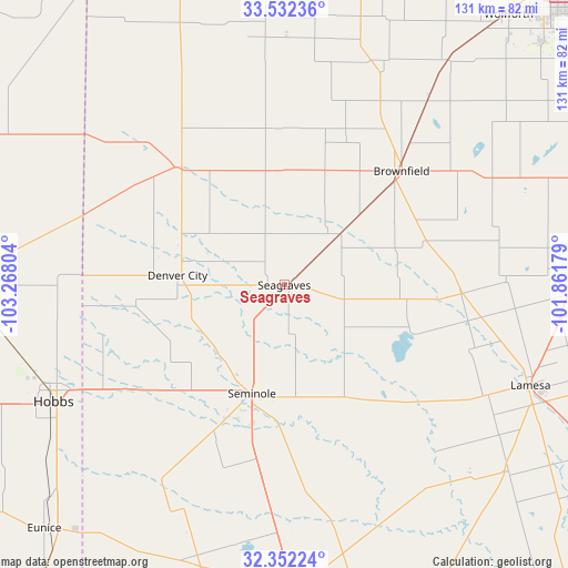
Seagraves GPS coordinates[2]
32° 56' 39.372" North, 102° 33' 53.676" West
| Map corner | latitude | longitude |
|---|---|---|
| Upper-left | 33.53236°, | -103.26804° |
| Center: | 32.94427°, | -102.56491° |
| Lower-right: | 32.35224°, | -101.86179° |
| Map W x H: | 131.2×131.2 km | = 81.5×81.5mi |
| max Lat: | 71.29058° ⇑85.4% North |
| Seagraves: | 32.94427° |
| min Lat: | ⇓14.6% South 19.06759° |
| min Long | Seagraves | max Long |
| -171.73463° | -102.56491° | -66.98998° |
| W 17.9%⇐ | ⇒82.1% E |
Elevation
Elevation of Seagraves is 1024 m = 3360 ft, and this is 729.2 m = 2392 ft above average elevation for this country.
| Max E: |
3189 m = 10463 ft | 6.4% |
| Seagraves | 1024 m 3360 ft | |
| Avg. | 294.8 m = 967 ft | |
Min E: |
-60 m = -197 ft | 93.6% |
See also: United States elevation on elevation.city.
Geographical zone
Seagraves is located in North temperate zone (between Tropic of Cancer and the Arctic Circle). Distance of this Northern Tropic circle is 1057.1 km =656.9 mi to South.| Distance of | km | miles | from Seagraves |
|---|---|---|---|
| North Pole | 6344 | 3942 | to North |
| Arctic Circle | 3738.1 | 2322.7 | to North |
| Tropic Cancer | 1057.1 | 656.9 | to South |
| Equator | 3663.1 | 2276.1 | to South |


Nearby cities:
15 places around Seagraves: (largest is in red/bold)
• Andrews
69.6 km =43.2 mi,  178°
178°
• Brownfield
37.8 km =23.5 mi,  45°
45°
• Denver City
24.8 km =15.4 mi,  275°
275°
• Hobbs
59.7 km =37.1 mi,  243°
243°
• Lamesa
61.8 km =38.4 mi,  111°
111°
• Levelland
73.6 km =45.7 mi,  13°
13°
• Lovington
73.1 km =45.4 mi,  269°
269°
• McKinney Acres
71.5 km =44.4 mi, 177°
• Meadow
55 km =34.2 mi,  37°
37°
• O'Donnell
68.4 km =42.5 mi,  88°
88°
• Plains
36.6 km =22.7 mi,  317°
317°
• Seminole
26.1 km =16.2 mi,  196°
196°
• Sundown
57.4 km =35.7 mi, 7°
• Tahoka
76 km =47.2 mi,  71°
71°
• Tatum
78.3 km =48.7 mi,  296°
296°
Sources, notices
• [Note1] Compared only with cities in United States existing in our database
• [Src1] Map data: © OpenStreetMap contributors (CC-BY-SA)
• [Src2] Other city data from geonames.org with taken over terms of usage.
• [Src3] Geographical zone / Annual Mean Temperature by Robert A. Rohde @ Wikipedia
