Hereford geodata
Hereford (Texas) is a seat of a second-order administrative division; located in United States in America/Chicago (GMT-5) time zone. With population of 15,021 people, there are 3244 cities with bigger population in this country. Compared to other cities in United States, 76.3% of cities are located further ↑North; 82% of cities are located further →East and 94.4% of cities have lower elevation than Hereford. Note1


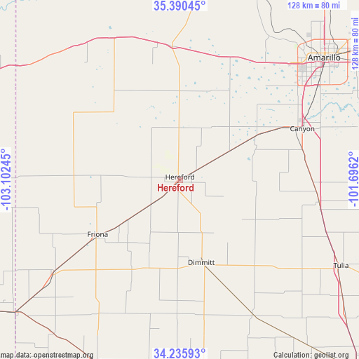
Hereford GPS coordinates[2]
34° 48' 54.756" North, 102° 23' 57.552" West
| Map corner | latitude | longitude |
|---|---|---|
| Upper-left | 35.39045°, | -103.10245° |
| Center: | 34.81521°, | -102.39932° |
| Lower-right: | 34.23593°, | -101.6962° |
| Map W x H: | 128.4×128.4 km | = 79.8×79.8mi |
| max Lat: | 71.29058° ⇑76.3% North |
| Hereford: | 34.81521° |
| min Lat: | ⇓23.7% South 19.06759° |
| min Long | Hereford | max Long |
| -171.73463° | -102.39932° | -66.98998° |
| W 18%⇐ | ⇒82% E |
Elevation
Elevation of Hereford is 1171 m = 3842 ft, and this is 876.2 m = 2875 ft above average elevation for this country.
| Max E: |
3189 m = 10463 ft | 5.6% |
| Hereford | 1171 m 3842 ft | |
| Avg. | 294.8 m = 967 ft | |
Min E: |
-60 m = -197 ft | 94.4% |
See also: United States elevation on elevation.city.
Geographical zone
Hereford is located in North temperate zone (between Tropic of Cancer and the Arctic Circle). Distance of this Northern Tropic circle is 1265.2 km =786.2 mi to South.| Distance of | km | miles | from Hereford |
|---|---|---|---|
| North Pole | 6136 | 3812.7 | to North |
| Arctic Circle | 3530.1 | 2193.5 | to North |
| Tropic Cancer | 1265.2 | 786.2 | to South |
| Equator | 3871.1 | 2405.4 | to South |


Nearby cities:
15 places around Hereford: (largest is in red/bold)
• Amarillo
68.7 km =42.7 mi,  48°
48°
• Bovina
55.5 km =34.5 mi,  232°
232°
• Bushland
51.8 km =32.2 mi,  36°
36°
• Canyon
47.5 km =29.5 mi,  67°
67°
• Dimmitt
30.5 km =19 mi,  164°
164°
• Earth
64.7 km =40.2 mi,  180°
180°
• Farwell
75.6 km =47 mi, 230°
• Friona
35.4 km =22 mi,  236°
236°
• Happy
50.4 km =31.3 mi,  99°
99°
• Hart
54.4 km =33.8 mi,  151°
151°
• Lake Tanglewood
62.5 km =38.8 mi,  63°
63°
• Muleshoe
71.9 km =44.7 mi,  204°
204°
• Olton
74.3 km =46.2 mi, 160°
• Tulia
66.3 km =41.2 mi,  117°
117°
• Vega
47.6 km =29.6 mi,  356°
356°
Sources, notices
• [Note1] Compared only with cities in United States existing in our database
• [Src1] Map data: © OpenStreetMap contributors (CC-BY-SA)
• [Src2] Other city data from geonames.org with taken over terms of usage.
• [Src3] Geographical zone / Annual Mean Temperature by Robert A. Rohde @ Wikipedia
