Post geodata
Post (Texas) is a seat of a second-order administrative division; located in United States in America/Chicago (GMT-5) time zone. With population of 5,349 people, there are 6881 cities with bigger population in this country. Compared to other cities in United States, 84.4% of cities are located further ↑North; 81.5% of cities are located further →East and 92% of cities have lower elevation than Post. Note1


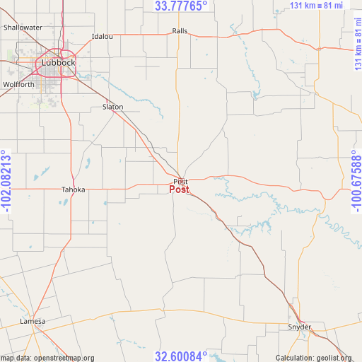
Post GPS coordinates[2]
33° 11' 28.392" North, 101° 22' 44.4" West
| Map corner | latitude | longitude |
|---|---|---|
| Upper-left | 33.77765°, | -102.08213° |
| Center: | 33.19122°, | -101.379° |
| Lower-right: | 32.60084°, | -100.67588° |
| Map W x H: | 130.8×130.8 km | = 81.3×81.3mi |
| max Lat: | 71.29058° ⇑84.4% North |
| Post: | 33.19122° |
| min Lat: | ⇓15.6% South 19.06759° |
| min Long | Post | max Long |
| -171.73463° | -101.379° | -66.98998° |
| W 18.5%⇐ | ⇒81.5% E |
Elevation
Elevation of Post is 795 m = 2608 ft, and this is 500.2 m = 1641 ft above average elevation for this country.
| Max E: |
3189 m = 10463 ft | 8% |
| Post | 795 m 2608 ft | |
| Avg. | 294.8 m = 967 ft | |
Min E: |
-60 m = -197 ft | 92% |
See also: United States elevation on elevation.city.
Geographical zone
Post is located in North temperate zone (between Tropic of Cancer and the Arctic Circle). Distance of this Northern Tropic circle is 1084.6 km =673.9 mi to South.| Distance of | km | miles | from Post |
|---|---|---|---|
| North Pole | 6316.5 | 3924.9 | to North |
| Arctic Circle | 3710.7 | 2305.7 | to North |
| Tropic Cancer | 1084.6 | 673.9 | to South |
| Equator | 3690.5 | 2293.2 | to South |


Nearby cities:
15 places around Post: (largest is in red/bold)
• Crosbyton
53.8 km =33.4 mi,  14°
14°
• Dickens
69.5 km =43.2 mi,  46°
46°
• Gail
47.2 km =29.3 mi,  187°
187°
• Idalou
59.9 km =37.2 mi,  331°
331°
• Lamesa
73.4 km =45.6 mi,  226°
226°
• Lorenzo
55.2 km =34.3 mi,  344°
344°
• Lubbock
61.7 km =38.3 mi,  314°
314°
• O'Donnell
49.3 km =30.6 mi,  239°
239°
• Ralls
53.7 km =33.4 mi,  359°
359°
• Ransom Canyon
47.2 km =29.3 mi,  323°
323°
• Slaton
36.8 km =22.9 mi, 318°
• Snyder
68 km =42.3 mi,  140°
140°
• Spur
58 km =36 mi,  56°
56°
• Tahoka
38.7 km =24 mi,  265°
265°
• Wolfforth
68.2 km =42.4 mi,  300°
300°
Sources, notices
• [Note1] Compared only with cities in United States existing in our database
• [Src1] Map data: © OpenStreetMap contributors (CC-BY-SA)
• [Src2] Other city data from geonames.org with taken over terms of usage.
• [Src3] Geographical zone / Annual Mean Temperature by Robert A. Rohde @ Wikipedia
