Gail geodata
Gail (Texas) is a seat of a second-order administrative division; located in United States in America/Chicago (GMT-5) time zone. With population of 231 people, there are 20999 cities with bigger population in this country. Compared to other cities in United States, 86.1% of cities are located further ↑North; 81.6% of cities are located further →East and 91.8% of cities have lower elevation than Gail. Note1


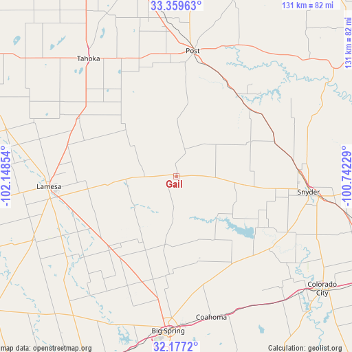
Gail GPS coordinates[2]
32° 46' 13.368" North, 101° 26' 43.476" West
| Map corner | latitude | longitude |
|---|---|---|
| Upper-left | 33.35963°, | -102.14854° |
| Center: | 32.77038°, | -101.44541° |
| Lower-right: | 32.1772°, | -100.74229° |
| Map W x H: | 131.5×131.5 km | = 81.7×81.7mi |
| max Lat: | 71.29058° ⇑86.1% North |
| Gail: | 32.77038° |
| min Lat: | ⇓13.9% South 19.06759° |
| min Long | Gail | max Long |
| -171.73463° | -101.44541° | -66.98998° |
| W 18.4%⇐ | ⇒81.6% E |
Elevation
Elevation of Gail is 779 m = 2556 ft, and this is 484.2 m = 1589 ft above average elevation for this country.
| Max E: |
3189 m = 10463 ft | 8.2% |
| Gail | 779 m 2556 ft | |
| Avg. | 294.8 m = 967 ft | |
Min E: |
-60 m = -197 ft | 91.8% |
See also: United States elevation on elevation.city.
Geographical zone
Gail is located in North temperate zone (between Tropic of Cancer and the Arctic Circle). Distance of this Northern Tropic circle is 1037.8 km =644.9 mi to South.| Distance of | km | miles | from Gail |
|---|---|---|---|
| North Pole | 6363.3 | 3954 | to North |
| Arctic Circle | 3757.4 | 2334.7 | to North |
| Tropic Cancer | 1037.8 | 644.9 | to South |
| Equator | 3643.7 | 2264.1 | to South |


Nearby cities:
15 places around Gail: (largest is in red/bold)
• Big Spring
57.9 km =36 mi,  183°
183°
• Brownfield
89.8 km =55.8 mi,  300°
300°
• Coahoma
54.3 km =33.7 mi,  166°
166°
• Colorado City
69 km =42.9 mi,  127°
127°
• Lamesa
47.4 km =29.5 mi,  265°
265°
• Loraine
79.4 km =49.3 mi,  120°
120°
• O'Donnell
42.1 km =26.2 mi, 300°
• Post
47.2 km =29.3 mi,  7°
7°
• Ransom Canyon
87.6 km =54.4 mi,  345°
345°
• Rotan
92 km =57.2 mi,  84°
84°
• Sand Springs
55 km =34.2 mi, 170°
• Slaton
76.4 km =47.5 mi, 346°
• Snyder
49.7 km =30.9 mi,  96°
96°
• Stanton
78.2 km =48.6 mi,  204°
204°
• Tahoka
54.8 km =34.1 mi,  323°
323°
Sources, notices
• [Note1] Compared only with cities in United States existing in our database
• [Src1] Map data: © OpenStreetMap contributors (CC-BY-SA)
• [Src2] Other city data from geonames.org with taken over terms of usage.
• [Src3] Geographical zone / Annual Mean Temperature by Robert A. Rohde @ Wikipedia
