Brownfield geodata
Brownfield (Texas) is a seat of a second-order administrative division; located in United States in America/Chicago (GMT-5) time zone. With population of 9,736 people, there are 4551 cities with bigger population in this country. Compared to other cities in United States, 84.4% of cities are located further ↑North; 81.9% of cities are located further →East and 93.5% of cities have lower elevation than Brownfield. Note1


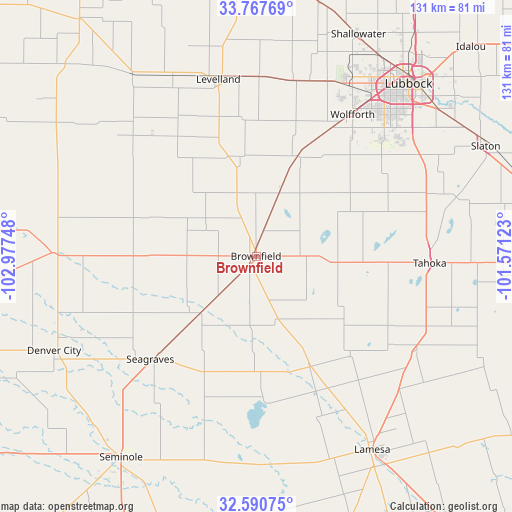
Brownfield GPS coordinates[2]
33° 10' 52.32" North, 102° 16' 27.66" West
| Map corner | latitude | longitude |
|---|---|---|
| Upper-left | 33.76769°, | -102.97748° |
| Center: | 33.1812°, | -102.27435° |
| Lower-right: | 32.59075°, | -101.57123° |
| Map W x H: | 130.9×130.9 km | = 81.3×81.3mi |
| max Lat: | 71.29058° ⇑84.4% North |
| Brownfield: | 33.1812° |
| min Lat: | ⇓15.6% South 19.06759° |
| min Long | Brownfield | max Long |
| -171.73463° | -102.27435° | -66.98998° |
| W 18.1%⇐ | ⇒81.9% E |
Elevation
Elevation of Brownfield is 1010 m = 3314 ft, and this is 715.2 m = 2346 ft above average elevation for this country.
| Max E: |
3189 m = 10463 ft | 6.5% |
| Brownfield | 1010 m 3314 ft | |
| Avg. | 294.8 m = 967 ft | |
Min E: |
-60 m = -197 ft | 93.5% |
See also: United States elevation on elevation.city.
Geographical zone
Brownfield is located in North temperate zone (between Tropic of Cancer and the Arctic Circle). Distance of this Northern Tropic circle is 1083.5 km =673.3 mi to South.| Distance of | km | miles | from Brownfield |
|---|---|---|---|
| North Pole | 6317.7 | 3925.6 | to North |
| Arctic Circle | 3711.8 | 2306.4 | to North |
| Tropic Cancer | 1083.5 | 673.3 | to South |
| Equator | 3689.4 | 2292.5 | to South |


Nearby cities:
15 places around Brownfield: (largest is in red/bold)
• Denver City
57 km =35.4 mi,  245°
245°
• Lamesa
57.8 km =35.9 mi,  148°
148°
• Levelland
46.2 km =28.7 mi,  347°
347°
• Lubbock
58.8 km =36.5 mi,  41°
41°
• Meadow
18.4 km =11.4 mi,  19°
19°
• O'Donnell
47.7 km =29.6 mi,  120°
120°
• Plains
51.5 km =32 mi,  270°
270°
• Ransom Canyon
67.7 km =42.1 mi,  54°
54°
• Seagraves
37.8 km =23.5 mi,  225°
225°
• Seminole
61.9 km =38.5 mi,  213°
213°
• Shallowater
62 km =38.5 mi, 24°
• Slaton
65.2 km =40.5 mi,  64°
64°
• Sundown
36.5 km =22.7 mi,  326°
326°
• Tahoka
44.8 km =27.8 mi,  92°
92°
• Wolfforth
43.7 km =27.2 mi,  34°
34°
Sources, notices
• [Note1] Compared only with cities in United States existing in our database
• [Src1] Map data: © OpenStreetMap contributors (CC-BY-SA)
• [Src2] Other city data from geonames.org with taken over terms of usage.
• [Src3] Geographical zone / Annual Mean Temperature by Robert A. Rohde @ Wikipedia
