Abilene geodata
Abilene (Texas) is a seat of a second-order administrative division; located in United States in America/Chicago (GMT-5) time zone. With population of 121,721 people, there are 257 cities with bigger population in this country. Compared to other cities in United States, 87.3% of cities are located further ↑North; 80.5% of cities are located further →East and 88.4% of cities have lower elevation than Abilene. Note1


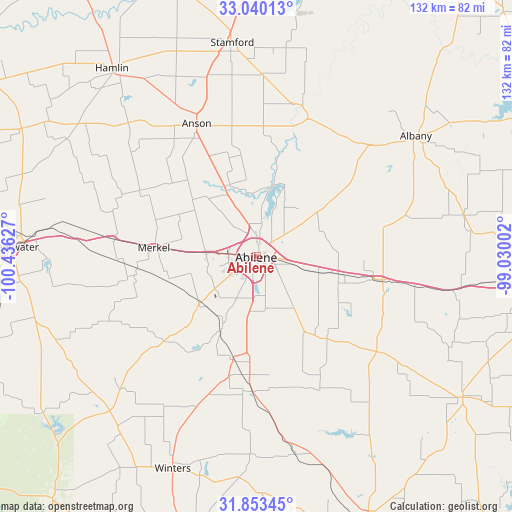
Abilene GPS coordinates[2]
32° 26' 55.464" North, 99° 43' 59.304" West
| Map corner | latitude | longitude |
|---|---|---|
| Upper-left | 33.04013°, | -100.43627° |
| Center: | 32.44874°, | -99.73314° |
| Lower-right: | 31.85345°, | -99.03002° |
| Map W x H: | 131.9×131.9 km | = 82×82mi |
| max Lat: | 71.29058° ⇑87.3% North |
| Abilene: | 32.44874° |
| min Lat: | ⇓12.7% South 19.06759° |
| min Long | Abilene | max Long |
| -171.73463° | -99.73314° | -66.98998° |
| W 19.5%⇐ | ⇒80.5% E |
Elevation
Elevation of Abilene is 525 m = 1722 ft, and this is 230.2 m = 755 ft above average elevation for this country.
| Max E: |
3189 m = 10463 ft | 11.6% |
| Abilene | 525 m 1722 ft | |
| Avg. | 294.8 m = 967 ft | |
Min E: |
-60 m = -197 ft | 88.4% |
See also: Abilene elevation on elevation.city.
Geographical zone
Abilene is located in North temperate zone (between Tropic of Cancer and the Arctic Circle). Distance of this Northern Tropic circle is 1002 km =622.6 mi to South.| Distance of | km | miles | from Abilene |
|---|---|---|---|
| North Pole | 6399.1 | 3976.2 | to North |
| Arctic Circle | 3793.2 | 2357 | to North |
| Tropic Cancer | 1002 | 622.6 | to South |
| Equator | 3608 | 2241.9 | to South |


Nearby cities:
15 places around Abilene: (largest is in red/bold)
• Albany
51 km =31.7 mi,  53°
53°
• Anson
37.5 km =23.3 mi,  335°
335°
• Baird
32.4 km =20.1 mi,  100°
100°
• Clyde
23 km =14.3 mi, 101°
• Cross Plains
64.3 km =40 mi,  123°
123°
• Hamlin
60.9 km =37.8 mi,  322°
322°
• Hawley
19.7 km =12.2 mi, 337°
• Merkel
26.4 km =16.4 mi,  275°
275°
• Potosi
15.1 km =9.4 mi,  151°
151°
• Roby
68.8 km =42.8 mi,  298°
298°
• Stamford
55.6 km =34.5 mi,  353°
353°
• Sweetwater
63.2 km =39.3 mi,  272°
272°
• Tuscola
27.3 km =17 mi,  192°
192°
• Tye
13 km =8.1 mi, 274°
• Winters
58.8 km =36.5 mi,  201°
201°
Sources, notices
• [Note1] Compared only with cities in United States existing in our database
• [Src1] Map data: © OpenStreetMap contributors (CC-BY-SA)
• [Src2] Other city data from geonames.org with taken over terms of usage.
• [Src3] Geographical zone / Annual Mean Temperature by Robert A. Rohde @ Wikipedia
