Tuscola geodata
Tuscola (Texas) is a populated place; located in United States in America/Chicago (GMT-5) time zone. With population of 744 people, there are 18268 cities with bigger population in this country. Compared to other cities in United States, 88.1% of cities are located further ↑North; 80.6% of cities are located further →East and 89.7% of cities have lower elevation than Tuscola. Note1


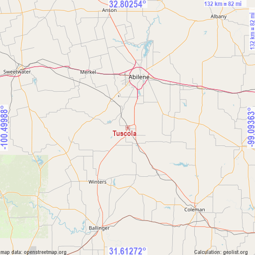
Tuscola GPS coordinates[2]
32° 12' 34.488" North, 99° 47' 48.3" West
| Map corner | latitude | longitude |
|---|---|---|
| Upper-left | 32.80254°, | -100.49988° |
| Center: | 32.20958°, | -99.79675° |
| Lower-right: | 31.61272°, | -99.09363° |
| Map W x H: | 132.3×132.3 km | = 82.2×82.2mi |
| max Lat: | 71.29058° ⇑88.1% North |
| Tuscola: | 32.20958° |
| min Lat: | ⇓11.9% South 19.06759° |
| min Long | Tuscola | max Long |
| -171.73463° | -99.79675° | -66.98998° |
| W 19.4%⇐ | ⇒80.6% E |
Elevation
Elevation of Tuscola is 603 m = 1978 ft, and this is 308.2 m = 1011 ft above average elevation for this country.
| Max E: |
3189 m = 10463 ft | 10.3% |
| Tuscola | 603 m 1978 ft | |
| Avg. | 294.8 m = 967 ft | |
Min E: |
-60 m = -197 ft | 89.7% |
See also: United States elevation on elevation.city.
Geographical zone
Tuscola is located in North temperate zone (between Tropic of Cancer and the Arctic Circle). Distance of this Northern Tropic circle is 975.5 km =606.1 mi to South.| Distance of | km | miles | from Tuscola |
|---|---|---|---|
| North Pole | 6425.7 | 3992.7 | to North |
| Arctic Circle | 3819.8 | 2373.5 | to North |
| Tropic Cancer | 975.5 | 606.1 | to South |
| Equator | 3581.4 | 2225.4 | to South |


Nearby cities:
15 places around Tuscola: (largest is in red/bold)
• Abilene
27.3 km =17 mi,  12°
12°
• Anson
61.5 km =38.2 mi,  351°
351°
• Baird
43 km =26.7 mi,  61°
61°
• Ballinger
54.3 km =33.7 mi,  195°
195°
• Bronte
58.8 km =36.5 mi,  232°
232°
• Clyde
35.9 km =22.3 mi,  52°
52°
• Coleman
55 km =34.2 mi,  140°
140°
• Cross Plains
60.1 km =37.3 mi,  98°
98°
• Hawley
44.8 km =27.8 mi,  357°
357°
• Merkel
35.4 km =22 mi,  325°
325°
• Potosi
18.7 km =11.6 mi,  44°
44°
• Santa Anna
68.6 km =42.6 mi, 139°
• Sweetwater
64.2 km =39.9 mi,  296°
296°
• Tye
28.5 km =17.7 mi, 345°
• Winters
32.2 km =20 mi,  209°
209°
Sources, notices
• [Note1] Compared only with cities in United States existing in our database
• [Src1] Map data: © OpenStreetMap contributors (CC-BY-SA)
• [Src2] Other city data from geonames.org with taken over terms of usage.
• [Src3] Geographical zone / Annual Mean Temperature by Robert A. Rohde @ Wikipedia
