Towner geodata
Towner (North Dakota) is a seat of a second-order administrative division; located in United States in America/Chicago (GMT-5) time zone. With population of 564 people, there are 20107 cities with bigger population in this country. Compared to other cities in United States, 99% of cities are located further ↓South; 80.9% of cities are located further →East and 86.3% of cities have lower elevation than Towner. Note1


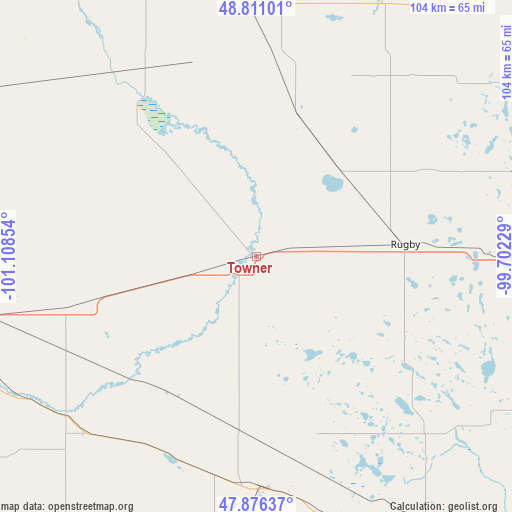
Towner GPS coordinates[2]
48° 20' 44.988" North, 100° 24' 19.476" West
| Map corner | latitude | longitude |
|---|---|---|
| Upper-left | 48.81101°, | -101.10854° |
| Center: | 48.34583°, | -100.40541° |
| Lower-right: | 47.87637°, | -99.70229° |
| Map W x H: | 103.9×103.9 km | = 64.6×64.6mi |
| max Lat: | 71.29058° ⇑1% North |
| Towner: | 48.34583° |
| min Lat: | ⇓99% South 19.06759° |
| min Long | Towner | max Long |
| -171.73463° | -100.40541° | -66.98998° |
| W 19.1%⇐ | ⇒80.9% E |
Elevation
Elevation of Towner is 450 m = 1476 ft, and this is 155.2 m = 509 ft above average elevation for this country.
| Max E: |
3189 m = 10463 ft | 13.7% |
| Towner | 450 m 1476 ft | |
| Avg. | 294.8 m = 967 ft | |
Min E: |
-60 m = -197 ft | 86.3% |
See also: United States elevation on elevation.city.
Geographical zone
Towner is located in North temperate zone (between Tropic of Cancer and the Arctic Circle). Distance of this North polar circle is 2025.6 km =1258.6 mi to North.| Distance of | km | miles | from Towner |
|---|---|---|---|
| North Pole | 4631.5 | 2877.9 | to North |
| Arctic Circle | 2025.6 | 1258.6 | to North |
| Tropic Cancer | 2769.6 | 1720.9 | to South |
| Equator | 5375.6 | 3340.2 | to South |


Nearby cities:
15 places around Towner: (largest is in red/bold)
• Belcourt
73.3 km =45.5 mi,  41°
41°
• Bottineau
53.6 km =33.3 mi,  356°
356°
• Burlington
76.1 km =47.3 mi,  264°
264°
• Cando
89.6 km =55.7 mi,  79°
79°
• Dunseith
57.8 km =35.9 mi,  25°
25°
• Green Acres
75.9 km =47.2 mi, 43°
• Harvey
73 km =45.4 mi,  151°
151°
• Minot
67.1 km =41.7 mi, 259°
• Minot Air Force Base
69.5 km =43.2 mi,  276°
276°
• Rolette
54.3 km =33.7 mi,  49°
49°
• Rolla
81.2 km =50.5 mi, 45°
• Rugby
30.3 km =18.8 mi,  85°
85°
• Shell Valley
64.1 km =39.8 mi, 38°
• Surrey
55.2 km =34.3 mi, 257°
• Velva
50.4 km =31.3 mi,  230°
230°
Sources, notices
• [Note1] Compared only with cities in United States existing in our database
• [Src1] Map data: © OpenStreetMap contributors (CC-BY-SA)
• [Src2] Other city data from geonames.org with taken over terms of usage.
• [Src3] Geographical zone / Annual Mean Temperature by Robert A. Rohde @ Wikipedia
