Bottineau geodata
Bottineau (North Dakota) is a seat of a second-order administrative division; located in United States in America/Chicago (GMT-5) time zone. With population of 2,343 people, there are 10984 cities with bigger population in this country. Compared to other cities in United States, 99.3% of cities are located further ↓South; 81% of cities are located further →East and 87.8% of cities have lower elevation than Bottineau. Note1
Administrative division(s):
- Level 1: North Dakota
- Level 2: Bottineau County
- Level 3: City of Bottineau


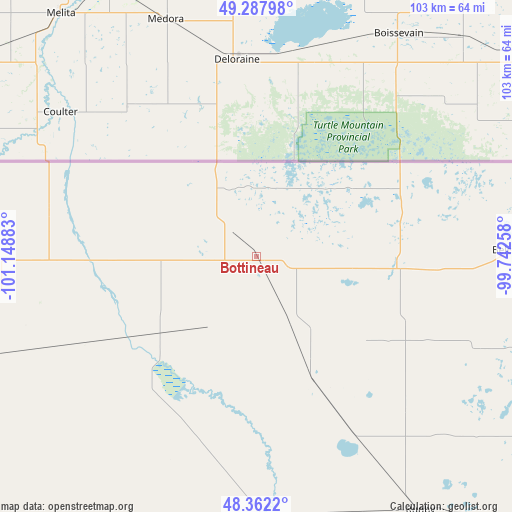
Bottineau GPS coordinates[2]
48° 49' 38.028" North, 100° 26' 44.52" West
| Map corner | latitude | longitude |
|---|---|---|
| Upper-left | 49.28798°, | -101.14883° |
| Center: | 48.82723°, | -100.4457° |
| Lower-right: | 48.3622°, | -99.74258° |
| Map W x H: | 102.9×102.9 km | = 63.9×63.9mi |
| max Lat: | 71.29058° ⇑0.7% North |
| Bottineau: | 48.82723° |
| min Lat: | ⇓99.3% South 19.06759° |
| min Long | Bottineau | max Long |
| -171.73463° | -100.4457° | -66.98998° |
| W 19%⇐ | ⇒81% E |
Elevation
Elevation of Bottineau is 498 m = 1634 ft, and this is 203.2 m = 667 ft above average elevation for this country.
| Max E: |
3189 m = 10463 ft | 12.2% |
| Bottineau | 498 m 1634 ft | |
| Avg. | 294.8 m = 967 ft | |
Min E: |
-60 m = -197 ft | 87.8% |
See also: United States elevation on elevation.city.
Geographical zone
Bottineau is located in North temperate zone (between Tropic of Cancer and the Arctic Circle). Distance of this North polar circle is 1972.1 km =1225.4 mi to North.| Distance of | km | miles | from Bottineau |
|---|---|---|---|
| North Pole | 4578 | 2844.6 | to North |
| Arctic Circle | 1972.1 | 1225.4 | to North |
| Tropic Cancer | 2823.2 | 1754.3 | to South |
| Equator | 5429.1 | 3373.5 | to South |


Nearby cities:
15 places around Bottineau: (largest is in red/bold)
• Belcourt
51.3 km =31.9 mi,  88°
88°
• Burlington
94.9 km =59 mi,  229°
229°
• Cando
98.4 km =61.1 mi,  112°
112°
• Dunseith
28.2 km =17.5 mi, 93°
• Green Acres
55.3 km =34.4 mi, 88°
• Minot
91.1 km =56.6 mi,  223°
223°
• Minot Air Force Base
79.7 km =49.5 mi,  235°
235°
• Mohall
78.5 km =48.8 mi,  264°
264°
• Rolette
48 km =29.8 mi, 112°
• Rolla
60.7 km =37.7 mi, 86°
• Rugby
60.7 km =37.7 mi,  147°
147°
• Shell Valley
42.7 km =26.5 mi, 94°
• Surrey
82.9 km =51.5 mi, 217°
• Towner
53.6 km =33.3 mi,  176°
176°
• Velva
92.9 km =57.7 mi,  202°
202°
Sources, notices
• [Note1] Compared only with cities in United States existing in our database
• [Src1] Map data: © OpenStreetMap contributors (CC-BY-SA)
• [Src2] Other city data from geonames.org with taken over terms of usage.
• [Src3] Geographical zone / Annual Mean Temperature by Robert A. Rohde @ Wikipedia
