Minot Air Force Base geodata
Minot Air Force Base (North Dakota) is a populated place; located in United States in America/Chicago (GMT-5) time zone. With population of 5,521 people, there are 6740 cities with bigger population in this country. Compared to other cities in United States, 99.1% of cities are located further ↓South; 81.5% of cities are located further →East and 87.6% of cities have lower elevation than Minot Air Force Base. Note1
Administrative division(s):
- Level 1: North Dakota
- Level 2: Ward County
- Level 3: Township of Waterford
Current local time in Minot Air Force Base:
02:02 PM, WednesdayDifference from your time zone: hours


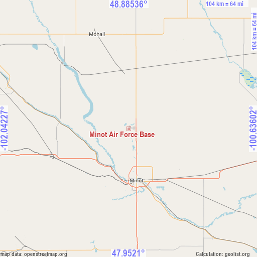
Minot Air Force Base GPS coordinates[2]
48° 25' 15.132" North, 101° 20' 20.904" West
| Map corner | latitude | longitude |
|---|---|---|
| Upper-left | 48.88536°, | -102.04227° |
| Center: | 48.42087°, | -101.33914° |
| Lower-right: | 47.9521°, | -100.63602° |
| Map W x H: | 103.8×103.8 km | = 64.5×64.5mi |
| max Lat: | 71.29058° ⇑0.9% North |
| Minot Air Force Base: | 48.42087° |
| min Lat: | ⇓99.1% South 19.06759° |
| min Long | Minot Air Force | max Long |
| -171.73463° | -101.33914° | -66.98998° |
| W 18.5%⇐ | ⇒81.5% E |
Elevation
Elevation of Minot Air Force Base is 491 m = 1611 ft, and this is 196.2 m = 644 ft above average elevation for this country.
| Max E: |
3189 m = 10463 ft | 12.4% |
| Minot Air Force Base | 491 m 1611 ft | |
| Avg. | 294.8 m = 967 ft | |
Min E: |
-60 m = -197 ft | 87.6% |
See also: United States elevation on elevation.city.
Geographical zone
Minot Air Force Base is located in North temperate zone (between Tropic of Cancer and the Arctic Circle). Distance of this North polar circle is 2017.3 km =1253.5 mi to North.| Distance of | km | miles | from Minot Air Force Base |
|---|---|---|---|
| North Pole | 4623.2 | 2872.7 | to North |
| Arctic Circle | 2017.3 | 1253.5 | to North |
| Tropic Cancer | 2778 | 1726.2 | to South |
| Equator | 5383.9 | 3345.4 | to South |


Nearby cities:
15 places around Minot Air Force Base: (largest is in red/bold)
• Berthold
31.7 km =19.7 mi,  247°
247°
• Bottineau
79.7 km =49.5 mi,  55°
55°
• Bowbells
79.1 km =49.2 mi,  302°
302°
• Burlington
17.5 km =10.9 mi,  202°
202°
• Garrison
85.7 km =53.3 mi,  183°
183°
• Kenmare
61.6 km =38.3 mi, 297°
• Minot
21.2 km =13.2 mi,  171°
171°
• Mohall
40.2 km =25 mi,  341°
341°
• New Town
98.3 km =61.1 mi,  240°
240°
• Parshall
78.6 km =48.8 mi,  228°
228°
• Rugby
99.3 km =61.7 mi,  93°
93°
• Stanley
78.5 km =48.8 mi,  261°
261°
• Surrey
25.5 km =15.8 mi,  143°
143°
• Towner
69.5 km =43.2 mi,  96°
96°
• Velva
50.7 km =31.5 mi, 143°
Sources, notices
• [Note1] Compared only with cities in United States existing in our database
• [Src1] Map data: © OpenStreetMap contributors (CC-BY-SA)
• [Src2] Other city data from geonames.org with taken over terms of usage.
• [Src3] Geographical zone / Annual Mean Temperature by Robert A. Rohde @ Wikipedia
