Casper geodata
Casper (Wyoming) is a seat of a second-order administrative division; located in United States in America/Denver (GMT-6) time zone. With population of 60,285 people, there are 740 cities with bigger population in this country. Compared to other cities in United States, 82.3% of cities are located further ↓South; 84.2% of cities are located further →East and 97.1% of cities have lower elevation than Casper. Note1


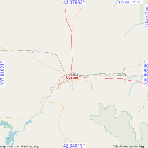
Casper GPS coordinates[2]
42° 51' 59.868" North, 106° 18' 47.088" West
| Map corner | latitude | longitude |
|---|---|---|
| Upper-left | 43.37983°, | -107.01621° |
| Center: | 42.86663°, | -106.31308° |
| Lower-right: | 42.34913°, | -105.60996° |
| Map W x H: | 114.6×114.6 km | = 71.2×71.2mi |
| max Lat: | 71.29058° ⇑17.7% North |
| Casper: | 42.86663° |
| min Lat: | ⇓82.3% South 19.06759° |
| min Long | Casper | max Long |
| -171.73463° | -106.31308° | -66.98998° |
| W 15.8%⇐ | ⇒84.2% E |
Elevation
Elevation of Casper is 1560 m = 5118 ft, and this is 1265.2 m = 4151 ft above average elevation for this country.
| Max E: |
3189 m = 10463 ft | 2.9% |
| Casper | 1560 m 5118 ft | |
| Avg. | 294.8 m = 967 ft | |
Min E: |
-60 m = -197 ft | 97.1% |
See also: Casper elevation on elevation.city.
Geographical zone
Casper is located in North temperate zone (between Tropic of Cancer and the Arctic Circle). Distance of this Northern Tropic circle is 2160.4 km =1342.4 mi to South.| Distance of | km | miles | from Casper |
|---|---|---|---|
| North Pole | 5240.7 | 3256.4 | to North |
| Arctic Circle | 2634.9 | 1637.3 | to North |
| Tropic Cancer | 2160.4 | 1342.4 | to South |
| Equator | 4766.3 | 2961.6 | to South |


Nearby cities:
15 places around Casper: (largest is in red/bold)
• Bar Nunn
5.8 km =3.6 mi,  334°
334°
• Douglas
76.9 km =47.8 mi,  98°
98°
• Evansville
3.7 km =2.3 mi, 101°
• Glenrock
35.9 km =22.3 mi,  90°
90°
• Guernsey
144.8 km =90 mi,  117°
117°
• Hanna
112.7 km =70 mi,  190°
190°
• Hartrandt
3.6 km =2.2 mi,  309°
309°
• Lusk
152.2 km =94.6 mi, 94°
• Mills
5.2 km =3.2 mi,  235°
235°
• Rawlins
141.7 km =88 mi,  212°
212°
• Saratoga
162.1 km =100.7 mi, 194°
• Shoshoni
151.7 km =94.3 mi,  285°
285°
• Vista West
9.9 km =6.2 mi,  270°
270°
• Wheatland
143.6 km =89.2 mi,  129°
129°
• Wright
118.7 km =73.8 mi,  34°
34°
Sources, notices
• [Note1] Compared only with cities in United States existing in our database
• [Src1] Map data: © OpenStreetMap contributors (CC-BY-SA)
• [Src2] Other city data from geonames.org with taken over terms of usage.
• [Src3] Geographical zone / Annual Mean Temperature by Robert A. Rohde @ Wikipedia
