Glenrock geodata
Glenrock (Wyoming) is a populated place; located in United States in America/Denver (GMT-6) time zone. With population of 2,598 people, there are 10400 cities with bigger population in this country. Compared to other cities in United States, 82.2% of cities are located further ↓South; 83.8% of cities are located further →East and 96.9% of cities have lower elevation than Glenrock. Note1


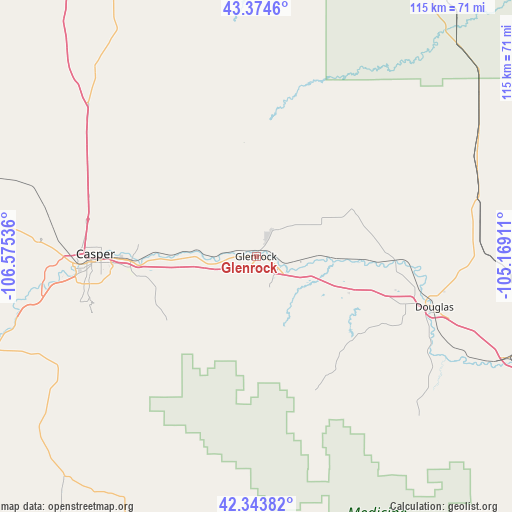
Glenrock GPS coordinates[2]
42° 51' 40.896" North, 105° 52' 20.028" West
| Map corner | latitude | longitude |
|---|---|---|
| Upper-left | 43.3746°, | -106.57536° |
| Center: | 42.86136°, | -105.87223° |
| Lower-right: | 42.34382°, | -105.16911° |
| Map W x H: | 114.6×114.6 km | = 71.2×71.2mi |
| max Lat: | 71.29058° ⇑17.8% North |
| Glenrock: | 42.86136° |
| min Lat: | ⇓82.2% South 19.06759° |
| min Long | Glenrock | max Long |
| -171.73463° | -105.87223° | -66.98998° |
| W 16.2%⇐ | ⇒83.8% E |
Elevation
Elevation of Glenrock is 1529 m = 5016 ft, and this is 1234.2 m = 4049 ft above average elevation for this country.
| Max E: |
3189 m = 10463 ft | 3.1% |
| Glenrock | 1529 m 5016 ft | |
| Avg. | 294.8 m = 967 ft | |
Min E: |
-60 m = -197 ft | 96.9% |
See also: United States elevation on elevation.city.
Geographical zone
Glenrock is located in North temperate zone (between Tropic of Cancer and the Arctic Circle). Distance of this Northern Tropic circle is 2159.8 km =1342 mi to South.| Distance of | km | miles | from Glenrock |
|---|---|---|---|
| North Pole | 5241.3 | 3256.8 | to North |
| Arctic Circle | 2635.4 | 1637.6 | to North |
| Tropic Cancer | 2159.8 | 1342 | to South |
| Equator | 4765.7 | 2961.3 | to South |


Nearby cities:
15 places around Glenrock: (largest is in red/bold)
• Antelope Valley-Crestview
155 km =96.3 mi,  11°
11°
• Bar Nunn
38.8 km =24.1 mi,  278°
278°
• Casper
35.9 km =22.3 mi,  270°
270°
• Douglas
41.5 km =25.8 mi,  105°
105°
• Evansville
32.3 km =20.1 mi, 269°
• Gillette
161.7 km =100.5 mi, 10°
• Guernsey
113.6 km =70.6 mi,  125°
125°
• Hanna
123.9 km =77 mi,  207°
207°
• Hartrandt
38.8 km =24.1 mi, 274°
• Lusk
116.3 km =72.3 mi,  95°
95°
• Mills
40.3 km =25 mi, 266°
• Sleepy Hollow
157.6 km =97.9 mi, 13°
• Vista West
45.8 km =28.5 mi, 270°
• Wheatland
117.2 km =72.8 mi,  139°
139°
• Wright
103.6 km =64.4 mi,  17°
17°
Sources, notices
• [Note1] Compared only with cities in United States existing in our database
• [Src1] Map data: © OpenStreetMap contributors (CC-BY-SA)
• [Src2] Other city data from geonames.org with taken over terms of usage.
• [Src3] Geographical zone / Annual Mean Temperature by Robert A. Rohde @ Wikipedia
