Hanna geodata
Hanna (Wyoming) is a populated place; located in United States in America/Denver (GMT-6) time zone. With population of 814 people, there are 17683 cities with bigger population in this country. Compared to other cities in United States, 74.5% of cities are located further ↓South; 84.3% of cities are located further →East and 99.3% of cities have lower elevation than Hanna. Note1


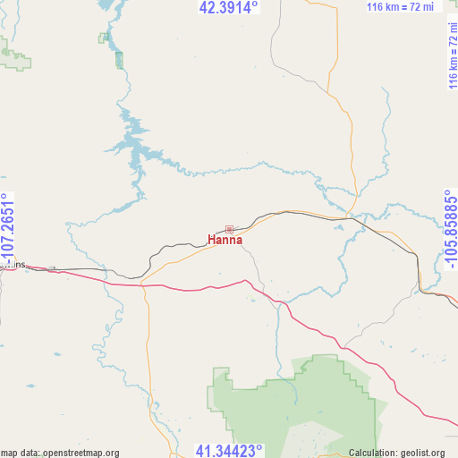
Hanna GPS coordinates[2]
41° 52' 11.856" North, 106° 33' 43.092" West
| Map corner | latitude | longitude |
|---|---|---|
| Upper-left | 42.3914°, | -107.2651° |
| Center: | 41.86996°, | -106.56197° |
| Lower-right: | 41.34423°, | -105.85885° |
| Map W x H: | 116.4×116.4 km | = 72.3×72.3mi |
| max Lat: | 71.29058° ⇑25.5% North |
| Hanna: | 41.86996° |
| min Lat: | ⇓74.5% South 19.06759° |
| min Long | Hanna | max Long |
| -171.73463° | -106.56197° | -66.98998° |
| W 15.7%⇐ | ⇒84.3% E |
Elevation
Elevation of Hanna is 2078 m = 6818 ft, and this is 1783.2 m = 5850 ft above average elevation for this country.
| Max E: |
3189 m = 10463 ft | 0.7% |
| Hanna | 2078 m 6818 ft | |
| Avg. | 294.8 m = 967 ft | |
Min E: |
-60 m = -197 ft | 99.3% |
See also: United States elevation on elevation.city.
Geographical zone
Hanna is located in North temperate zone (between Tropic of Cancer and the Arctic Circle). Distance of this Northern Tropic circle is 2049.6 km =1273.6 mi to South.| Distance of | km | miles | from Hanna |
|---|---|---|---|
| North Pole | 5351.6 | 3325.3 | to North |
| Arctic Circle | 2745.7 | 1706.1 | to North |
| Tropic Cancer | 2049.6 | 1273.6 | to South |
| Equator | 4655.5 | 2892.8 | to South |


Nearby cities:
15 places around Hanna: (largest is in red/bold)
• Bar Nunn
117.4 km =72.9 mi,  8°
8°
• Casper
112.7 km =70 mi, 10°
• Douglas
138.5 km =86.1 mi,  44°
44°
• Evansville
112.7 km =70 mi, 12°
• Glenrock
123.9 km =77 mi,  27°
27°
• Guernsey
156.7 km =97.4 mi,  73°
73°
• Hartrandt
114.5 km =71.1 mi, 8°
• Laramie
101.9 km =63.3 mi,  127°
127°
• Mills
109.1 km =67.8 mi, 8°
• Rawlins
56.7 km =35.2 mi,  261°
261°
• Saratoga
50.4 km =31.3 mi,  203°
203°
• Steamboat Springs
155.6 km =96.7 mi,  188°
188°
• Vista West
111.3 km =69.2 mi, 5°
• Walden
128.7 km =80 mi,  169°
169°
• Wheatland
134.6 km =83.6 mi,  81°
81°
Sources, notices
• [Note1] Compared only with cities in United States existing in our database
• [Src1] Map data: © OpenStreetMap contributors (CC-BY-SA)
• [Src2] Other city data from geonames.org with taken over terms of usage.
• [Src3] Geographical zone / Annual Mean Temperature by Robert A. Rohde @ Wikipedia
