Wheatland geodata
Wheatland (Wyoming) is a seat of a second-order administrative division; located in United States in America/Denver (GMT-6) time zone. With population of 3,659 people, there are 8644 cities with bigger population in this country. Compared to other cities in United States, 76.1% of cities are located further ↓South; 83.2% of cities are located further →East and 96.3% of cities have lower elevation than Wheatland. Note1


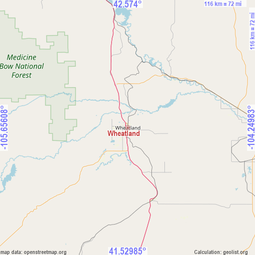
Wheatland GPS coordinates[2]
42° 3' 14.652" North, 104° 57' 10.62" West
| Map corner | latitude | longitude |
|---|---|---|
| Upper-left | 42.574°, | -105.65608° |
| Center: | 42.05407°, | -104.95295° |
| Lower-right: | 41.52985°, | -104.24983° |
| Map W x H: | 116.1×116.1 km | = 72.1×72.1mi |
| max Lat: | 71.29058° ⇑23.9% North |
| Wheatland: | 42.05407° |
| min Lat: | ⇓76.1% South 19.06759° |
| min Long | Wheatland | max Long |
| -171.73463° | -104.95295° | -66.98998° |
| W 16.8%⇐ | ⇒83.2% E |
Elevation
Elevation of Wheatland is 1449 m = 4754 ft, and this is 1154.2 m = 3787 ft above average elevation for this country.
| Max E: |
3189 m = 10463 ft | 3.7% |
| Wheatland | 1449 m 4754 ft | |
| Avg. | 294.8 m = 967 ft | |
Min E: |
-60 m = -197 ft | 96.3% |
See also: United States elevation on elevation.city.
Geographical zone
Wheatland is located in North temperate zone (between Tropic of Cancer and the Arctic Circle). Distance of this Northern Tropic circle is 2070.1 km =1286.3 mi to South.| Distance of | km | miles | from Wheatland |
|---|---|---|---|
| North Pole | 5331.1 | 3312.6 | to North |
| Arctic Circle | 2725.2 | 1693.4 | to North |
| Tropic Cancer | 2070.1 | 1286.3 | to South |
| Equator | 4676 | 2905.5 | to South |


Nearby cities:
15 places around Wheatland: (largest is in red/bold)
• Cheyenne
102.2 km =63.5 mi,  173°
173°
• Douglas
86 km =53.4 mi,  335°
335°
• Fox Farm-College
105.7 km =65.7 mi, 172°
• Gering
109.9 km =68.3 mi,  103°
103°
• Guernsey
29.6 km =18.4 mi,  35°
35°
• Harrison
112.6 km =70 mi,  51°
51°
• Laramie
98.1 km =61 mi,  212°
212°
• Lusk
88.9 km =55.2 mi,  27°
27°
• Mitchell
95.4 km =59.3 mi, 97°
• Morrill
85.4 km =53.1 mi, 96°
• Ranchettes
93.9 km =58.3 mi, 171°
• Scottsbluff
108.3 km =67.3 mi, 101°
• South Greeley
107.1 km =66.5 mi, 173°
• Terrytown
109.2 km =67.9 mi, 102°
• Torrington
63.5 km =39.5 mi,  89°
89°
Sources, notices
• [Note1] Compared only with cities in United States existing in our database
• [Src1] Map data: © OpenStreetMap contributors (CC-BY-SA)
• [Src2] Other city data from geonames.org with taken over terms of usage.
• [Src3] Geographical zone / Annual Mean Temperature by Robert A. Rohde @ Wikipedia
