Vichadero geodata
Vichadero (Rivera) is a populated place; located in Uruguay in America/Montevideo (GMT-3) time zone. With population of 4,170 people, there are 59 cities with bigger population in this country. Compared to other cities in Uruguay, 90.2% of cities are located further ↓South; 86.9% of cities are located further ←West and 97.5% of cities have lower elevation than Vichadero. Note1


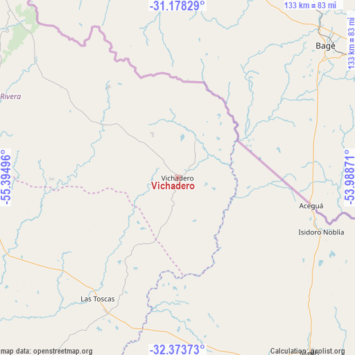
Vichadero GPS coordinates[2]
31° 46' 40.584" South, 54° 41' 30.588" West
| Map corner | latitude | longitude |
|---|---|---|
| Upper-left | -31.17829°, | -55.39496° |
| Center: | -31.77794°, | -54.69183° |
| Lower-right: | -32.37373°, | -53.98871° |
| Map W x H: | 132.9×132.9 km | = 82.6×82.6mi |
| max Lat: | -30.25966° ⇑9.8% North |
| Vichadero: | -31.77794° |
| min Lat: | ⇓90.2% South -34.94747° |
| min Long | Vichadero | max Long |
| -58.41176° | -54.69183° | -53.38583° |
| W 86.9%⇐ | ⇒13.1% E |
Elevation
Elevation of Vichadero is 241 m = 791 ft, and this is 170.4 m = 559 ft above average elevation for this country.
| Max E: |
294 m = 965 ft | 2.5% |
| Vichadero | 241 m 791 ft | |
| Avg. | 70.6 m = 232 ft | |
Min E: |
2 m = 7 ft | 97.5% |
See also: Uruguay elevation on elevation.city.
Geographical zone
Vichadero is located in South temperate zone (between Tropic of Capricorn and the Antarctic Circle). Distance of this Southern Tropic circle is 927.5 km =576.3 mi to North.| Distance of | km | miles | from Vichadero |
|---|---|---|---|
| Equator | 3533.4 | 2195.6 | to North |
| Tropic Capricorn | 927.5 | 576.3 | to North |
| Antarctic Circle | 3867.8 | 2403.3 | to South |
| South Pole | 6473.7 | 4022.6 | to South |


Nearby cities:
15 places around Vichadero: (largest is in red/bold)
• Aceguá
51 km =31.7 mi,  101°
101°
• Blanquillo
141.1 km =87.7 mi,  218°
218°
• Curtina
140.6 km =87.4 mi,  252°
252°
• Isidoro Noblía
57.5 km =35.7 mi,  110°
110°
• La Paloma
134.7 km =83.7 mi, 218°
• Melo
82.3 km =51.1 mi,  143°
143°
• Minas de Corrales
77.1 km =47.9 mi,  287°
287°
• Rivera
126.8 km =78.8 mi,  319°
319°
• Río Branco
153 km =95.1 mi,  126°
126°
• Santa Clara de Olimar
129.5 km =80.5 mi,  190°
190°
• Tacuarembó
122.1 km =75.9 mi,  273°
273°
• Tranqueras
119.1 km =74 mi,  302°
302°
• Treinta y Tres
164.4 km =102.2 mi,  169°
169°
• Tupambaé
117.6 km =73.1 mi,  183°
183°
• Vergara
147.7 km =91.8 mi,  151°
151°
Sources, notices
• [Note1] Compared only with cities in Uruguay existing in our database
• [Src1] Map data: © OpenStreetMap contributors (CC-BY-SA)
• [Src2] Other city data from geonames.org with taken over terms of usage.
• [Src3] Geographical zone / Annual Mean Temperature by Robert A. Rohde @ Wikipedia
