Vergara geodata
Vergara (Treinta y Tres) is a populated place; located in Uruguay in America/Montevideo (GMT-3) time zone. With population of 3,998 people, there are 62 cities with bigger population in this country. Compared to other cities in Uruguay, 74.6% of cities are located further ↓South; 95.9% of cities are located further ←West and 68% of cities have higher elevation than Vergara. Note1


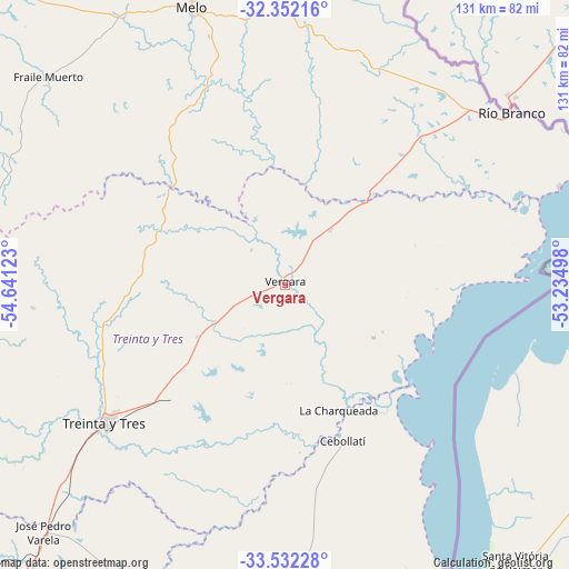
Vergara GPS coordinates[2]
32° 56' 39.084" South, 53° 56' 17.16" West
| Map corner | latitude | longitude |
|---|---|---|
| Upper-left | -32.35216°, | -54.64123° |
| Center: | -32.94419°, | -53.9381° |
| Lower-right: | -33.53228°, | -53.23498° |
| Map W x H: | 131.2×131.2 km | = 81.5×81.5mi |
| max Lat: | -30.25966° ⇑25.4% North |
| Vergara: | -32.94419° |
| min Lat: | ⇓74.6% South -34.94747° |
| min Long | Vergara | max Long |
| -58.41176° | -53.9381° | -53.38583° |
| W 95.9%⇐ | ⇒4.1% E |
Elevation
Elevation of Vergara is 31 m = 102 ft, and this is 39.6 m = 130 ft below average elevation for this country.
| Max E: |
294 m = 965 ft | 68% |
| Avg. | 70.6 m = 232 ft | |
| Vergara | 31 m = 102 ft | |
Min E: |
2 m = 7 ft | 32% |
See also: Uruguay elevation on elevation.city.
Geographical zone
Vergara is located in South temperate zone (between Tropic of Capricorn and the Antarctic Circle). Distance of this Southern Tropic circle is 1057.1 km =656.9 mi to North.| Distance of | km | miles | from Vergara |
|---|---|---|---|
| Equator | 3663.1 | 2276.1 | to North |
| Tropic Capricorn | 1057.1 | 656.9 | to North |
| Antarctic Circle | 3738.1 | 2322.7 | to South |
| South Pole | 6344 | 3942 | to South |


Nearby cities:
15 places around Vergara: (largest is in red/bold)
• Aceguá
121.1 km =75.2 mi,  349°
349°
• Cebollatí
38.3 km =23.8 mi,  159°
159°
• Chui
94.9 km =59 mi,  152°
152°
• Dieciocho de Julio
89.5 km =55.6 mi, 156°
• Isidoro Noblía
110.6 km =68.7 mi, 350°
• José Batlle y Ordóñez
124.1 km =77.1 mi,  242°
242°
• José Pedro Varela
79.5 km =49.4 mi,  224°
224°
• Lascano
84.7 km =52.6 mi,  197°
197°
• Melo
67.3 km =41.8 mi,  341°
341°
• Río Branco
64.4 km =40 mi,  53°
53°
• Santa Clara de Olimar
93.9 km =58.3 mi,  271°
271°
• Treinta y Tres
52.5 km =32.6 mi,  232°
232°
• Tupambaé
78.3 km =48.7 mi,  279°
279°
• Velázquez
125.5 km =78 mi,  194°
194°
• Villa Sara
56.5 km =35.1 mi, 232°
Sources, notices
• [Note1] Compared only with cities in Uruguay existing in our database
• [Src1] Map data: © OpenStreetMap contributors (CC-BY-SA)
• [Src2] Other city data from geonames.org with taken over terms of usage.
• [Src3] Geographical zone / Annual Mean Temperature by Robert A. Rohde @ Wikipedia
