Melo geodata
Melo (Cerro Largo) is a seat of a first-order administrative division; located in Uruguay in America/Montevideo (GMT-3) time zone. With population of 51,023 people, there are 7 cities with bigger population in this country. Compared to other cities in Uruguay, 83.6% of cities are located further ↓South; 92.6% of cities are located further ←West and 80.3% of cities have lower elevation than Melo. Note1


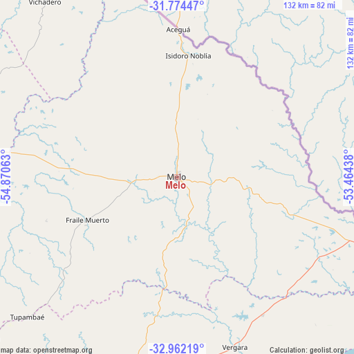
Melo GPS coordinates[2]
32° 22' 13.008" South, 54° 10' 3" West
| Map corner | latitude | longitude |
|---|---|---|
| Upper-left | -31.77447°, | -54.87063° |
| Center: | -32.37028°, | -54.1675° |
| Lower-right: | -32.96219°, | -53.46438° |
| Map W x H: | 132.1×132.1 km | = 82.1×82.1mi |
| max Lat: | -30.25966° ⇑16.4% North |
| Melo: | -32.37028° |
| min Lat: | ⇓83.6% South -34.94747° |
| min Long | Melo | max Long |
| -58.41176° | -54.1675° | -53.38583° |
| W 92.6%⇐ | ⇒7.4% E |
Elevation
Elevation of Melo is 115 m = 377 ft, and this is 44.4 m = 146 ft above average elevation for this country.
| Max E: |
294 m = 965 ft | 19.7% |
| Melo | 115 m 377 ft | |
| Avg. | 70.6 m = 232 ft | |
Min E: |
2 m = 7 ft | 80.3% |
See also: Melo elevation on elevation.city.
Geographical zone
Melo is located in South temperate zone (between Tropic of Capricorn and the Antarctic Circle). Distance of this Southern Tropic circle is 993.3 km =617.2 mi to North.| Distance of | km | miles | from Melo |
|---|---|---|---|
| Equator | 3599.2 | 2236.4 | to North |
| Tropic Capricorn | 993.3 | 617.2 | to North |
| Antarctic Circle | 3801.9 | 2362.4 | to South |
| South Pole | 6407.8 | 3981.6 | to South |


Nearby cities:
15 places around Melo: (largest is in red/bold)
• Aceguá
55.4 km =34.4 mi,  0°
0°
• Blanquillo
144.3 km =89.7 mi,  252°
252°
• Cebollatí
105.6 km =65.6 mi,  160°
160°
• Isidoro Noblía
45.6 km =28.3 mi,  5°
5°
• José Batlle y Ordóñez
150.7 km =93.6 mi,  216°
216°
• José Pedro Varela
125.4 km =77.9 mi,  195°
195°
• La Paloma
138.4 km =86 mi, 253°
• Lascano
144.8 km =90 mi,  181°
181°
• Río Branco
77.6 km =48.2 mi,  109°
109°
• Santa Clara de Olimar
95.2 km =59.2 mi,  229°
229°
• Treinta y Tres
98.1 km =61 mi,  191°
191°
• Tupambaé
76.2 km =47.3 mi, 227°
• Vergara
67.3 km =41.8 mi, 161°
• Vichadero
82.3 km =51.1 mi,  323°
323°
• Villa Sara
101 km =62.8 mi, 193°
Sources, notices
• [Note1] Compared only with cities in Uruguay existing in our database
• [Src1] Map data: © OpenStreetMap contributors (CC-BY-SA)
• [Src2] Other city data from geonames.org with taken over terms of usage.
• [Src3] Geographical zone / Annual Mean Temperature by Robert A. Rohde @ Wikipedia
