Aceguá geodata
Aceguá (Cerro Largo) is a populated place; located in Uruguay in America/Montevideo (GMT-3) time zone. With population of 1,501 people, there are 100 cities with bigger population in this country. Compared to other cities in Uruguay, 89.3% of cities are located further ↓South; 94.3% of cities are located further ←West and 93.4% of cities have lower elevation than Aceguá. Note1


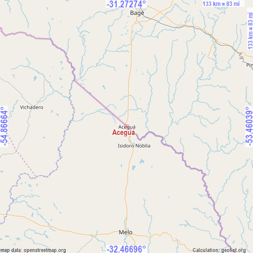
Aceguá GPS coordinates[2]
31° 52' 18.408" South, 54° 9' 48.636" West
| Map corner | latitude | longitude |
|---|---|---|
| Upper-left | -31.27274°, | -54.86664° |
| Center: | -31.87178°, | -54.16351° |
| Lower-right: | -32.46696°, | -53.46039° |
| Map W x H: | 132.8×132.8 km | = 82.5×82.5mi |
| max Lat: | -30.25966° ⇑10.7% North |
| Aceguá: | -31.87178° |
| min Lat: | ⇓89.3% South -34.94747° |
| min Long | Aceguá | max Long |
| -58.41176° | -54.16351° | -53.38583° |
| W 94.3%⇐ | ⇒5.7% E |
Elevation
Elevation of Aceguá is 177 m = 581 ft, and this is 106.4 m = 349 ft above average elevation for this country.
| Max E: |
294 m = 965 ft | 6.6% |
| Aceguá | 177 m 581 ft | |
| Avg. | 70.6 m = 232 ft | |
Min E: |
2 m = 7 ft | 93.4% |
See also: Uruguay elevation on elevation.city.
Geographical zone
Aceguá is located in South temperate zone (between Tropic of Capricorn and the Antarctic Circle). Distance of this Southern Tropic circle is 937.9 km =582.8 mi to North.| Distance of | km | miles | from Aceguá |
|---|---|---|---|
| Equator | 3543.8 | 2202 | to North |
| Tropic Capricorn | 937.9 | 582.8 | to North |
| Antarctic Circle | 3857.4 | 2396.9 | to South |
| South Pole | 6463.3 | 4016.1 | to South |


Nearby cities:
15 places around Aceguá: (largest is in red/bold)
• Blanquillo
170.2 km =105.8 mi,  234°
234°
• Cebollatí
158.9 km =98.7 mi,  167°
167°
• Isidoro Noblía
10.8 km =6.7 mi,  159°
159°
• La Paloma
163.8 km =101.8 mi, 234°
• Melo
55.4 km =34.4 mi,  180°
180°
• Minas de Corrales
128 km =79.5 mi,  285°
285°
• Rivera
170 km =105.6 mi,  309°
309°
• Río Branco
109 km =67.7 mi,  137°
137°
• Santa Clara de Olimar
137.9 km =85.7 mi,  212°
212°
• Tranqueras
167.9 km =104.3 mi,  296°
296°
• Treinta y Tres
152.8 km =94.9 mi,  187°
187°
• Tupambaé
121 km =75.2 mi, 207°
• Vergara
121.1 km =75.2 mi, 169°
• Vichadero
51 km =31.7 mi,  281°
281°
• Villa Sara
155.5 km =96.6 mi, 188°
Sources, notices
• [Note1] Compared only with cities in Uruguay existing in our database
• [Src1] Map data: © OpenStreetMap contributors (CC-BY-SA)
• [Src2] Other city data from geonames.org with taken over terms of usage.
• [Src3] Geographical zone / Annual Mean Temperature by Robert A. Rohde @ Wikipedia
