Piriápolis geodata
Piriápolis (Maldonado) is a populated place; located in Uruguay in America/Montevideo (GMT-3) time zone. With population of 7,968 people, there are 41 cities with bigger population in this country. Compared to other cities in Uruguay, 96.7% of cities are located further ↑North; 77.9% of cities are located further ←West and 82.8% of cities have higher elevation than Piriápolis. Note1


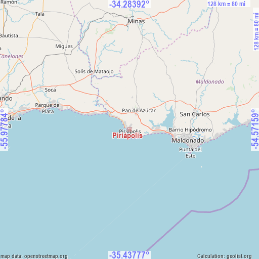
Piriápolis GPS coordinates[2]
34° 51' 46.332" South, 55° 16' 28.956" West
| Map corner | latitude | longitude |
|---|---|---|
| Upper-left | -34.28392°, | -55.97784° |
| Center: | -34.86287°, | -55.27471° |
| Lower-right: | -35.43777°, | -54.57159° |
| Map W x H: | 128.3×128.3 km | = 79.7×79.7mi |
| max Lat: | -30.25966° ⇑96.7% North |
| Piriápolis: | -34.86287° |
| min Lat: | ⇓3.3% South -34.94747° |
| min Long | Piriápolis | max Long |
| -58.41176° | -55.27471° | -53.38583° |
| W 77.9%⇐ | ⇒22.1% E |
Elevation
Elevation of Piriápolis is 17 m = 56 ft, and this is 53.6 m = 176 ft below average elevation for this country.
| Max E: |
294 m = 965 ft | 82.8% |
| Avg. | 70.6 m = 232 ft | |
| Piriápolis | 17 m = 56 ft | |
Min E: |
2 m = 7 ft | 17.2% |
See also: Uruguay elevation on elevation.city.
Geographical zone
Piriápolis is located in South temperate zone (between Tropic of Capricorn and the Antarctic Circle). Distance of this Southern Tropic circle is 1270.5 km =789.5 mi to North.| Distance of | km | miles | from Piriápolis |
|---|---|---|---|
| Equator | 3876.4 | 2408.7 | to North |
| Tropic Capricorn | 1270.5 | 789.5 | to North |
| Antarctic Circle | 3524.8 | 2190.2 | to South |
| South Pole | 6130.7 | 3809.4 | to South |


Nearby cities:
15 places around Piriápolis: (largest is in red/bold)
• Atlántida
45.3 km =28.1 mi,  282°
282°
• Empalme Olmos
59.4 km =36.9 mi,  288°
288°
• La Floresta
39 km =24.2 mi, 287°
• Las Toscas
42.8 km =26.6 mi, 289°
• Maldonado
29.9 km =18.6 mi,  97°
97°
• Migues
52.8 km =32.8 mi,  322°
322°
• Minas
54.3 km =33.7 mi,  3°
3°
• Montes
48.8 km =30.3 mi,  327°
327°
• Pan de Azúcar
10 km =6.2 mi,  20°
20°
• Pando
64.5 km =40.1 mi, 284°
• Punta del Este
32.5 km =20.2 mi,  106°
106°
• San Carlos
33.5 km =20.8 mi,  76°
76°
• San Jacinto
65 km =40.4 mi,  302°
302°
• Soca
43.8 km =27.2 mi, 296°
• Solís de Mataojo
34.2 km =21.3 mi, 328°
Sources, notices
• [Note1] Compared only with cities in Uruguay existing in our database
• [Src1] Map data: © OpenStreetMap contributors (CC-BY-SA)
• [Src2] Other city data from geonames.org with taken over terms of usage.
• [Src3] Geographical zone / Annual Mean Temperature by Robert A. Rohde @ Wikipedia
