Minas geodata
Minas (Lavalleja) is a seat of a first-order administrative division; located in Uruguay in America/Montevideo (GMT-3) time zone. With population of 38,025 people, there are 10 cities with bigger population in this country. Compared to other cities in Uruguay, 62.3% of cities are located further ↑North; 78.7% of cities are located further ←West and 84.4% of cities have lower elevation than Minas. Note1


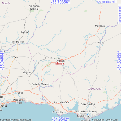
Minas GPS coordinates[2]
34° 22' 33.204" South, 55° 14' 15.756" West
| Map corner | latitude | longitude |
|---|---|---|
| Upper-left | -33.79356°, | -55.94084° |
| Center: | -34.37589°, | -55.23771° |
| Lower-right: | -34.9542°, | -54.53459° |
| Map W x H: | 129.1×129.1 km | = 80.2×80.2mi |
| max Lat: | -30.25966° ⇑62.3% North |
| Minas: | -34.37589° |
| min Lat: | ⇓37.7% South -34.94747° |
| min Long | Minas | max Long |
| -58.41176° | -55.23771° | -53.38583° |
| W 78.7%⇐ | ⇒21.3% E |
Elevation
Elevation of Minas is 134 m = 440 ft, and this is 63.4 m = 208 ft above average elevation for this country.
| Max E: |
294 m = 965 ft | 15.6% |
| Minas | 134 m 440 ft | |
| Avg. | 70.6 m = 232 ft | |
Min E: |
2 m = 7 ft | 84.4% |
See also: Uruguay elevation on elevation.city.
Geographical zone
Minas is located in South temperate zone (between Tropic of Capricorn and the Antarctic Circle). Distance of this Southern Tropic circle is 1216.3 km =755.8 mi to North.| Distance of | km | miles | from Minas |
|---|---|---|---|
| Equator | 3822.2 | 2375 | to North |
| Tropic Capricorn | 1216.3 | 755.8 | to North |
| Antarctic Circle | 3578.9 | 2223.8 | to South |
| South Pole | 6184.8 | 3843.1 | to South |


Nearby cities:
15 places around Minas: (largest is in red/bold)
• Aiguá
48.1 km =29.9 mi,  66°
66°
• Alejandro Gallinal
63.6 km =39.5 mi,  333°
333°
• Casupá
48.6 km =30.2 mi,  309°
309°
• La Floresta
58.6 km =36.4 mi,  223°
223°
• Las Toscas
59.2 km =36.8 mi,  227°
227°
• Mariscala
56.4 km =35 mi,  48°
48°
• Migues
37.9 km =23.5 mi,  250°
250°
• Montes
32.5 km =20.2 mi, 246°
• Pan de Azúcar
44.8 km =27.8 mi,  179°
179°
• Piriápolis
54.3 km =33.7 mi, 183°
• San Carlos
54.7 km =34 mi,  147°
147°
• San Jacinto
61.1 km =38 mi, 252°
• Soca
54.6 km =33.9 mi, 231°
• Solís de Mataojo
32.6 km =20.3 mi, 220°
• Tala
48.4 km =30.1 mi,  274°
274°
Sources, notices
• [Note1] Compared only with cities in Uruguay existing in our database
• [Src1] Map data: © OpenStreetMap contributors (CC-BY-SA)
• [Src2] Other city data from geonames.org with taken over terms of usage.
• [Src3] Geographical zone / Annual Mean Temperature by Robert A. Rohde @ Wikipedia
