Montes geodata
Montes (Canelones) is a populated place; located in Uruguay in America/Montevideo (GMT-3) time zone. With population of 1,687 people, there are 97 cities with bigger population in this country. Compared to other cities in Uruguay, 70.5% of cities are located further ↑North; 73.8% of cities are located further ←West and 63.9% of cities have higher elevation than Montes. Note1


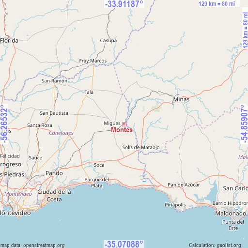
Montes GPS coordinates[2]
34° 29' 36.204" South, 55° 33' 43.884" West
| Map corner | latitude | longitude |
|---|---|---|
| Upper-left | -33.91187°, | -56.26532° |
| Center: | -34.49339°, | -55.56219° |
| Lower-right: | -35.07088°, | -54.85907° |
| Map W x H: | 128.9×128.9 km | = 80.1×80.1mi |
| max Lat: | -30.25966° ⇑70.5% North |
| Montes: | -34.49339° |
| min Lat: | ⇓29.5% South -34.94747° |
| min Long | Montes | max Long |
| -58.41176° | -55.56219° | -53.38583° |
| W 73.8%⇐ | ⇒26.2% E |
Elevation
Elevation of Montes is 39 m = 128 ft, and this is 31.6 m = 104 ft below average elevation for this country.
| Max E: |
294 m = 965 ft | 63.9% |
| Avg. | 70.6 m = 232 ft | |
| Montes | 39 m = 128 ft | |
Min E: |
2 m = 7 ft | 36.1% |
See also: Uruguay elevation on elevation.city.
Geographical zone
Montes is located in South temperate zone (between Tropic of Capricorn and the Antarctic Circle). Distance of this Southern Tropic circle is 1229.4 km =763.9 mi to North.| Distance of | km | miles | from Montes |
|---|---|---|---|
| Equator | 3835.3 | 2383.1 | to North |
| Tropic Capricorn | 1229.4 | 763.9 | to North |
| Antarctic Circle | 3565.9 | 2215.7 | to South |
| South Pole | 6171.8 | 3835 | to South |


Nearby cities:
15 places around Montes: (largest is in red/bold)
• Atlántida
35.8 km =22.2 mi,  210°
210°
• Empalme Olmos
37.8 km =23.5 mi,  233°
233°
• La Floresta
31.1 km =19.3 mi,  200°
200°
• Las Toscas
30.2 km =18.8 mi, 207°
• Migues
6.1 km =3.8 mi,  276°
276°
• Minas
32.5 km =20.2 mi,  66°
66°
• Pan de Azúcar
43.6 km =27.1 mi,  136°
136°
• Pando
44 km =27.3 mi,  235°
235°
• San Bautista
36.8 km =22.9 mi, 279°
• San Jacinto
28.9 km =18 mi,  258°
258°
• San Ramón
42.5 km =26.4 mi,  301°
301°
• Santa Rosa
43.6 km =27.1 mi,  269°
269°
• Soca
24.8 km =15.4 mi, 211°
• Solís de Mataojo
14.6 km =9.1 mi, 143°
• Tala
24.9 km =15.5 mi,  312°
312°
Sources, notices
• [Note1] Compared only with cities in Uruguay existing in our database
• [Src1] Map data: © OpenStreetMap contributors (CC-BY-SA)
• [Src2] Other city data from geonames.org with taken over terms of usage.
• [Src3] Geographical zone / Annual Mean Temperature by Robert A. Rohde @ Wikipedia
