Tala geodata
Tala (Canelones) is a populated place; located in Uruguay in America/Montevideo (GMT-3) time zone. With population of 4,949 people, there are 55 cities with bigger population in this country. Compared to other cities in Uruguay, 60.7% of cities are located further ↑North; 64.8% of cities are located further ←West and 68.9% of cities have lower elevation than Tala. Note1


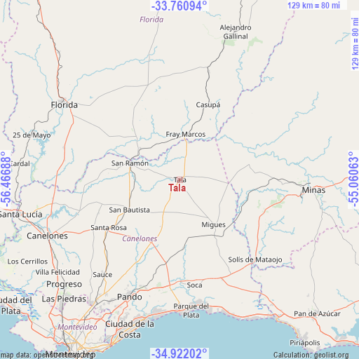
Tala GPS coordinates[2]
34° 20' 36.564" South, 55° 45' 49.5" West
| Map corner | latitude | longitude |
|---|---|---|
| Upper-left | -33.76094°, | -56.46688° |
| Center: | -34.34349°, | -55.76375° |
| Lower-right: | -34.92202°, | -55.06063° |
| Map W x H: | 129.1×129.1 km | = 80.2×80.2mi |
| max Lat: | -30.25966° ⇑60.7% North |
| Tala: | -34.34349° |
| min Lat: | ⇓39.3% South -34.94747° |
| min Long | Tala | max Long |
| -58.41176° | -55.76375° | -53.38583° |
| W 64.8%⇐ | ⇒35.2% E |
Elevation
Elevation of Tala is 84 m = 276 ft, and this is 13.4 m = 44 ft above average elevation for this country.
| Max E: |
294 m = 965 ft | 31.1% |
| Tala | 84 m 276 ft | |
| Avg. | 70.6 m = 232 ft | |
Min E: |
2 m = 7 ft | 68.9% |
See also: Uruguay elevation on elevation.city.
Geographical zone
Tala is located in South temperate zone (between Tropic of Capricorn and the Antarctic Circle). Distance of this Southern Tropic circle is 1212.7 km =753.5 mi to North.| Distance of | km | miles | from Tala |
|---|---|---|---|
| Equator | 3818.6 | 2372.8 | to North |
| Tropic Capricorn | 1212.7 | 753.5 | to North |
| Antarctic Circle | 3582.5 | 2226.1 | to South |
| South Pole | 6188.4 | 3845.3 | to South |


Nearby cities:
15 places around Tala: (largest is in red/bold)
• Casupá
29.1 km =18.1 mi,  21°
21°
• Empalme Olmos
41.1 km =25.5 mi,  196°
196°
• La Floresta
46.5 km =28.9 mi,  170°
170°
• Las Toscas
43.6 km =27.1 mi, 174°
• Migues
20.3 km =12.6 mi,  142°
142°
• Montes
24.9 km =15.5 mi,  132°
132°
• Pando
45.2 km =28.1 mi, 203°
• San Antonio
31.4 km =19.5 mi,  247°
247°
• San Bautista
20.9 km =13 mi,  238°
238°
• San Jacinto
24.5 km =15.2 mi, 203°
• San Ramón
18.6 km =11.6 mi,  288°
288°
• Santa Rosa
30.5 km =19 mi, 235°
• Sauce
44 km =27.3 mi,  218°
218°
• Soca
38.3 km =23.8 mi, 171°
• Solís de Mataojo
39.3 km =24.4 mi, 136°
Sources, notices
• [Note1] Compared only with cities in Uruguay existing in our database
• [Src1] Map data: © OpenStreetMap contributors (CC-BY-SA)
• [Src2] Other city data from geonames.org with taken over terms of usage.
• [Src3] Geographical zone / Annual Mean Temperature by Robert A. Rohde @ Wikipedia
