Carmelo geodata
Carmelo (Colonia) is a populated place; located in Uruguay in America/Montevideo (GMT-3) time zone. With population of 16,921 people, there are 25 cities with bigger population in this country. Compared to other cities in Uruguay, 50.8% of cities are located further ↓South; 97.5% of cities are located further →East and 90.2% of cities have higher elevation than Carmelo. Note1


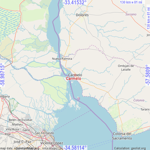
Carmelo GPS coordinates[2]
34° 0' 0.828" South, 58° 17' 2.472" West
| Map corner | latitude | longitude |
|---|---|---|
| Upper-left | -33.41532°, | -58.98715° |
| Center: | -34.00023°, | -58.28402° |
| Lower-right: | -34.58114°, | -57.5809° |
| Map W x H: | 129.6×129.6 km | = 80.5×80.5mi |
| max Lat: | -30.25966° ⇑49.2% North |
| Carmelo: | -34.00023° |
| min Lat: | ⇓50.8% South -34.94747° |
| min Long | Carmelo | max Long |
| -58.41176° | -58.28402° | -53.38583° |
| W 2.5%⇐ | ⇒97.5% E |
Elevation
Elevation of Carmelo is 13 m = 43 ft, and this is 57.6 m = 189 ft below average elevation for this country.
| Max E: |
294 m = 965 ft | 90.2% |
| Avg. | 70.6 m = 232 ft | |
| Carmelo | 13 m = 43 ft | |
Min E: |
2 m = 7 ft | 9.8% |
See also: Uruguay elevation on elevation.city.
Geographical zone
Carmelo is located in South temperate zone (between Tropic of Capricorn and the Antarctic Circle). Distance of this Southern Tropic circle is 1174.6 km =729.9 mi to North.| Distance of | km | miles | from Carmelo |
|---|---|---|---|
| Equator | 3780.5 | 2349.1 | to North |
| Tropic Capricorn | 1174.6 | 729.9 | to North |
| Antarctic Circle | 3620.7 | 2249.8 | to South |
| South Pole | 6226.6 | 3869 | to South |


Nearby cities:
15 places around Carmelo: (largest is in red/bold)
• Cardona
85.6 km =53.2 mi,  80°
80°
• Colonia del Sacramento
65.7 km =40.8 mi,  141°
141°
• Dolores
52.6 km =32.7 mi,  6°
6°
• Florencio Sánchez
85.3 km =53 mi, 80°
• Fray Bentos
98.3 km =61.1 mi,  358°
358°
• José Enrique Rodó
77.3 km =48 mi,  64°
64°
• Juan L. Lacaze
89.5 km =55.6 mi,  121°
121°
• Mercedes
86.4 km =53.7 mi,  15°
15°
• Nueva Palmira
18.6 km =11.6 mi,  320°
320°
• Ombúes de Lavalle
44.3 km =27.5 mi, 80°
• Palmitas
70.7 km =43.9 mi,  39°
39°
• Rosario
92.9 km =57.7 mi,  112°
112°
• Santa Catalina
77 km =47.8 mi,  72°
72°
• Tarariras
68 km =42.3 mi, 115°
• Villa Soriano
67 km =41.6 mi, 357°
Sources, notices
• [Note1] Compared only with cities in Uruguay existing in our database
• [Src1] Map data: © OpenStreetMap contributors (CC-BY-SA)
• [Src2] Other city data from geonames.org with taken over terms of usage.
• [Src3] Geographical zone / Annual Mean Temperature by Robert A. Rohde @ Wikipedia
