Dolores geodata
Dolores (Soriano) is a populated place; located in Uruguay in America/Montevideo (GMT-3) time zone. With population of 15,880 people, there are 29 cities with bigger population in this country. Compared to other cities in Uruguay, 60.7% of cities are located further ↓South; 96.7% of cities are located further →East and 78.7% of cities have higher elevation than Dolores. Note1


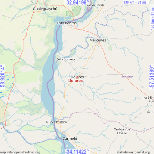
Dolores GPS coordinates[2]
33° 31' 48.324" South, 58° 13' 1.236" West
| Map corner | latitude | longitude |
|---|---|---|
| Upper-left | -32.94199°, | -58.92014° |
| Center: | -33.53009°, | -58.21701° |
| Lower-right: | -34.11422°, | -57.51389° |
| Map W x H: | 130.3×130.3 km | = 81×81mi |
| max Lat: | -30.25966° ⇑39.3% North |
| Dolores: | -33.53009° |
| min Lat: | ⇓60.7% South -34.94747° |
| min Long | Dolores | max Long |
| -58.41176° | -58.21701° | -53.38583° |
| W 3.3%⇐ | ⇒96.7% E |
Elevation
Elevation of Dolores is 22 m = 72 ft, and this is 48.6 m = 159 ft below average elevation for this country.
| Max E: |
294 m = 965 ft | 78.7% |
| Avg. | 70.6 m = 232 ft | |
| Dolores | 22 m = 72 ft | |
Min E: |
2 m = 7 ft | 21.3% |
See also: Uruguay elevation on elevation.city.
Geographical zone
Dolores is located in South temperate zone (between Tropic of Capricorn and the Antarctic Circle). Distance of this Southern Tropic circle is 1122.3 km =697.4 mi to North.| Distance of | km | miles | from Dolores |
|---|---|---|---|
| Equator | 3728.2 | 2316.6 | to North |
| Tropic Capricorn | 1122.3 | 697.4 | to North |
| Antarctic Circle | 3673 | 2282.3 | to South |
| South Pole | 6278.9 | 3901.5 | to South |


Nearby cities:
15 places around Dolores: (largest is in red/bold)
• Cardona
87.1 km =54.1 mi,  115°
115°
• Carmelo
52.6 km =32.7 mi,  186°
186°
• Florencio Sánchez
87.2 km =54.2 mi, 116°
• Fray Bentos
46.8 km =29.1 mi,  349°
349°
• José Enrique Rodó
66.1 km =41.1 mi,  106°
106°
• Mercedes
35.4 km =22 mi,  29°
29°
• Nueva Palmira
41.9 km =26 mi,  205°
205°
• Nuevo Berlín
62.9 km =39.1 mi,  13°
13°
• Ombúes de Lavalle
58.9 km =36.6 mi,  140°
140°
• Palmitas
38.7 km =24 mi,  86°
86°
• San Javier
96.5 km =60 mi,  4°
4°
• Santa Catalina
73.4 km =45.6 mi, 113°
• Tarariras
98.7 km =61.3 mi,  145°
145°
• Villa Soriano
17.6 km =10.9 mi,  326°
326°
• Young
107.6 km =66.9 mi, 30°
Sources, notices
• [Note1] Compared only with cities in Uruguay existing in our database
• [Src1] Map data: © OpenStreetMap contributors (CC-BY-SA)
• [Src2] Other city data from geonames.org with taken over terms of usage.
• [Src3] Geographical zone / Annual Mean Temperature by Robert A. Rohde @ Wikipedia
