Aguas Corrientes geodata
Aguas Corrientes (Canelones) is a populated place; located in Uruguay in America/Montevideo (GMT-3) time zone. With population of 1,101 people, there are 116 cities with bigger population in this country. Compared to other cities in Uruguay, 72.1% of cities are located further ↑North; 62.3% of cities are located further →East and 86.9% of cities have higher elevation than Aguas Corrientes. Note1


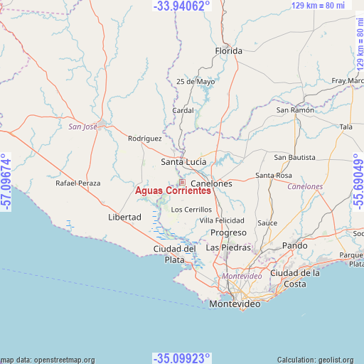
Aguas Corrientes GPS coordinates[2]
34° 31' 18.984" South, 56° 23' 36.996" West
| Map corner | latitude | longitude |
|---|---|---|
| Upper-left | -33.94062°, | -57.09674° |
| Center: | -34.52194°, | -56.39361° |
| Lower-right: | -35.09923°, | -55.69049° |
| Map W x H: | 128.8×128.8 km | = 80×80mi |
| max Lat: | -30.25966° ⇑72.1% North |
| Aguas Corrientes: | -34.52194° |
| min Lat: | ⇓27.9% South -34.94747° |
| min Long | Aguas Corriente | max Long |
| -58.41176° | -56.39361° | -53.38583° |
| W 37.7%⇐ | ⇒62.3% E |
Elevation
Elevation of Aguas Corrientes is 14 m = 46 ft, and this is 56.6 m = 186 ft below average elevation for this country.
| Max E: |
294 m = 965 ft | 86.9% |
| Avg. | 70.6 m = 232 ft | |
| Aguas Corrientes | 14 m = 46 ft | |
Min E: |
2 m = 7 ft | 13.1% |
See also: Uruguay elevation on elevation.city.
Geographical zone
Aguas Corrientes is located in South temperate zone (between Tropic of Capricorn and the Antarctic Circle). Distance of this Southern Tropic circle is 1232.6 km =765.9 mi to North.| Distance of | km | miles | from Aguas Corrientes |
|---|---|---|---|
| Equator | 3838.5 | 2385.1 | to North |
| Tropic Capricorn | 1232.6 | 765.9 | to North |
| Antarctic Circle | 3562.7 | 2213.8 | to South |
| South Pole | 6168.6 | 3833 | to South |


Nearby cities:
15 places around Aguas Corrientes: (largest is in red/bold)
• 25 de Agosto
12.3 km =7.6 mi,  356°
356°
• Canelones
10.6 km =6.6 mi,  90°
90°
• Cardal
25.7 km =16 mi,  0°
0°
• Delta del Tigre
27.1 km =16.8 mi,  174°
174°
• Juanicó
15.2 km =9.4 mi,  122°
122°
• La Paz
30.6 km =19 mi,  149°
149°
• Las Piedras
28.1 km =17.5 mi, 145°
• Libertad
24 km =14.9 mi,  238°
238°
• Los Cerrillos
9.8 km =6.1 mi,  159°
159°
• Progreso
22.8 km =14.2 mi,  135°
135°
• Puntas de Valdéz
29 km =18 mi,  255°
255°
• Rodríguez
20.5 km =12.7 mi,  319°
319°
• San Antonio
29.8 km =18.5 mi,  74°
74°
• Santa Lucía
7.6 km =4.7 mi, 2°
• Santiago Vázquez
30.1 km =18.7 mi, 172°
Sources, notices
• [Note1] Compared only with cities in Uruguay existing in our database
• [Src1] Map data: © OpenStreetMap contributors (CC-BY-SA)
• [Src2] Other city data from geonames.org with taken over terms of usage.
• [Src3] Geographical zone / Annual Mean Temperature by Robert A. Rohde @ Wikipedia
