Cardal geodata
Cardal (Florida) is a populated place; located in Uruguay in America/Montevideo (GMT-3) time zone. With population of 1,291 people, there are 107 cities with bigger population in this country. Compared to other cities in Uruguay, 56.6% of cities are located further ↑North; 60.7% of cities are located further →East and 51.6% of cities have lower elevation than Cardal. Note1


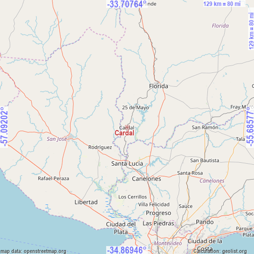
Cardal GPS coordinates[2]
34° 17' 26.016" South, 56° 23' 20.004" West
| Map corner | latitude | longitude |
|---|---|---|
| Upper-left | -33.70764°, | -57.09202° |
| Center: | -34.29056°, | -56.38889° |
| Lower-right: | -34.86946°, | -55.68577° |
| Map W x H: | 129.2×129.2 km | = 80.3×80.3mi |
| max Lat: | -30.25966° ⇑56.6% North |
| Cardal: | -34.29056° |
| min Lat: | ⇓43.4% South -34.94747° |
| min Long | Cardal | max Long |
| -58.41176° | -56.38889° | -53.38583° |
| W 39.3%⇐ | ⇒60.7% E |
Elevation
Elevation of Cardal is 53 m = 174 ft, and this is 17.6 m = 58 ft below average elevation for this country.
| Max E: |
294 m = 965 ft | 48.4% |
| Avg. | 70.6 m = 232 ft | |
| Cardal | 53 m = 174 ft | |
Min E: |
2 m = 7 ft | 51.6% |
See also: Uruguay elevation on elevation.city.
Geographical zone
Cardal is located in South temperate zone (between Tropic of Capricorn and the Antarctic Circle). Distance of this Southern Tropic circle is 1206.8 km =749.9 mi to North.| Distance of | km | miles | from Cardal |
|---|---|---|---|
| Equator | 3812.8 | 2369.2 | to North |
| Tropic Capricorn | 1206.8 | 749.9 | to North |
| Antarctic Circle | 3588.4 | 2229.7 | to South |
| South Pole | 6194.3 | 3849 | to South |


Nearby cities:
15 places around Cardal: (largest is in red/bold)
• 25 de Agosto
13.5 km =8.4 mi,  185°
185°
• 25 de Mayo
12.2 km =7.6 mi,  21°
21°
• Aguas Corrientes
25.7 km =16 mi,  180°
180°
• Canelones
27.8 km =17.3 mi,  158°
158°
• Florida
27 km =16.8 mi,  36°
36°
• Juanicó
36 km =22.4 mi, 159°
• Los Cerrillos
35.1 km =21.8 mi, 175°
• Puntas de Valdéz
43.5 km =27 mi,  221°
221°
• Rodríguez
17 km =10.6 mi,  233°
233°
• San Antonio
33.5 km =20.8 mi,  122°
122°
• San Bautista
42.9 km =26.7 mi,  112°
112°
• San José de Mayo
30.3 km =18.8 mi,  260°
260°
• San Ramón
39.8 km =24.7 mi,  90°
90°
• Santa Lucía
18.1 km =11.2 mi, 180°
• Santa Rosa
39.6 km =24.6 mi,  125°
125°
Sources, notices
• [Note1] Compared only with cities in Uruguay existing in our database
• [Src1] Map data: © OpenStreetMap contributors (CC-BY-SA)
• [Src2] Other city data from geonames.org with taken over terms of usage.
• [Src3] Geographical zone / Annual Mean Temperature by Robert A. Rohde @ Wikipedia
