Canelones geodata
Canelones is a seat of a first-order administrative division; located in Uruguay in America/Montevideo (GMT-3) time zone. With population of 19,698 people, there are 23 cities with bigger population in this country. Compared to other cities in Uruguay, 73% of cities are located further ↑North; 54.9% of cities are located further →East and 81.1% of cities have higher elevation than Canelones. Note1


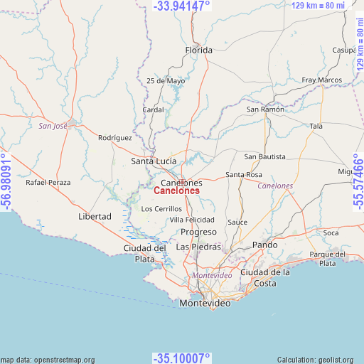
Canelones GPS coordinates[2]
34° 31' 22.008" South, 56° 16' 40.008" West
| Map corner | latitude | longitude |
|---|---|---|
| Upper-left | -33.94147°, | -56.98091° |
| Center: | -34.52278°, | -56.27778° |
| Lower-right: | -35.10007°, | -55.57466° |
| Map W x H: | 128.8×128.8 km | = 80×80mi |
| max Lat: | -30.25966° ⇑73% North |
| Canelones: | -34.52278° |
| min Lat: | ⇓27% South -34.94747° |
| min Long | Canelones | max Long |
| -58.41176° | -56.27778° | -53.38583° |
| W 45.1%⇐ | ⇒54.9% E |
Elevation
Elevation of Canelones is 18 m = 59 ft, and this is 52.6 m = 173 ft below average elevation for this country.
| Max E: |
294 m = 965 ft | 81.1% |
| Avg. | 70.6 m = 232 ft | |
| Canelones | 18 m = 59 ft | |
Min E: |
2 m = 7 ft | 18.9% |
See also: Uruguay elevation on elevation.city.
Geographical zone
Canelones is located in South temperate zone (between Tropic of Capricorn and the Antarctic Circle). Distance of this Southern Tropic circle is 1232.7 km =766 mi to North.| Distance of | km | miles | from Canelones |
|---|---|---|---|
| Equator | 3838.6 | 2385.2 | to North |
| Tropic Capricorn | 1232.7 | 766 | to North |
| Antarctic Circle | 3562.6 | 2213.7 | to South |
| South Pole | 6168.5 | 3832.9 | to South |


Nearby cities:
15 places around Canelones: (largest is in red/bold)
• 25 de Agosto
16.8 km =10.4 mi,  317°
317°
• Aguas Corrientes
10.6 km =6.6 mi,  270°
270°
• Cardal
27.8 km =17.3 mi,  338°
338°
• Delta del Tigre
28.1 km =17.5 mi,  196°
196°
• Juanicó
8.3 km =5.2 mi,  164°
164°
• La Paz
26.8 km =16.7 mi,  169°
169°
• Las Piedras
23.7 km =14.7 mi, 166°
• Los Cerrillos
11.6 km =7.2 mi,  218°
218°
• Progreso
17 km =10.6 mi, 161°
• Rodríguez
28.6 km =17.8 mi,  303°
303°
• San Antonio
19.8 km =12.3 mi,  66°
66°
• Santa Lucía
12.9 km =8 mi,  306°
306°
• Santa Rosa
22.1 km =13.7 mi,  82°
82°
• Sauce
24.2 km =15 mi,  126°
126°
• Toledo
29.2 km =18.1 mi,  145°
145°
Sources, notices
• [Note1] Compared only with cities in Uruguay existing in our database
• [Src1] Map data: © OpenStreetMap contributors (CC-BY-SA)
• [Src2] Other city data from geonames.org with taken over terms of usage.
• [Src3] Geographical zone / Annual Mean Temperature by Robert A. Rohde @ Wikipedia
