San Antonio geodata
San Antonio (Canelones) is a populated place; located in Uruguay in America/Montevideo (GMT-3) time zone. With population of 1,453 people, there are 102 cities with bigger population in this country. Compared to other cities in Uruguay, 66.4% of cities are located further ↑North; 52.5% of cities are located further ←West and 52.5% of cities have higher elevation than San Antonio. Note1


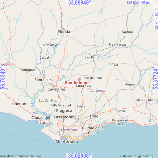
San Antonio GPS coordinates[2]
34° 27' 4.68" South, 56° 4' 49.296" West
| Map corner | latitude | longitude |
|---|---|---|
| Upper-left | -33.86949°, | -56.78349° |
| Center: | -34.4513°, | -56.08036° |
| Lower-right: | -35.02908°, | -55.37724° |
| Map W x H: | 128.9×128.9 km | = 80.1×80.1mi |
| max Lat: | -30.25966° ⇑66.4% North |
| San Antonio: | -34.4513° |
| min Lat: | ⇓33.6% South -34.94747° |
| min Long | San Antonio | max Long |
| -58.41176° | -56.08036° | -53.38583° |
| W 52.5%⇐ | ⇒47.5% E |
Elevation
Elevation of San Antonio is 52 m = 171 ft, and this is 18.6 m = 61 ft below average elevation for this country.
| Max E: |
294 m = 965 ft | 52.5% |
| Avg. | 70.6 m = 232 ft | |
| San Antonio | 52 m = 171 ft | |
Min E: |
2 m = 7 ft | 47.5% |
See also: Uruguay elevation on elevation.city.
Geographical zone
San Antonio is located in South temperate zone (between Tropic of Capricorn and the Antarctic Circle). Distance of this Southern Tropic circle is 1224.7 km =761 mi to North.| Distance of | km | miles | from San Antonio |
|---|---|---|---|
| Equator | 3830.6 | 2380.2 | to North |
| Tropic Capricorn | 1224.7 | 761 | to North |
| Antarctic Circle | 3570.5 | 2218.6 | to South |
| South Pole | 6176.4 | 3837.8 | to South |


Nearby cities:
15 places around San Antonio: (largest is in red/bold)
• 25 de Agosto
29.8 km =18.5 mi,  278°
278°
• Aguas Corrientes
29.8 km =18.5 mi,  254°
254°
• Canelones
19.8 km =12.3 mi, 246°
• Joaquín Suárez
31.8 km =19.8 mi,  172°
172°
• Juanicó
22.5 km =14 mi,  224°
224°
• Los Cerrillos
30.5 km =19 mi,  235°
235°
• Pando
31.6 km =19.6 mi,  159°
159°
• Progreso
27.1 km =16.8 mi,  207°
207°
• San Bautista
11.2 km =7 mi,  83°
83°
• San Jacinto
21.8 km =13.5 mi,  118°
118°
• San Ramón
21.1 km =13.1 mi,  32°
32°
• Santa Lucía
28.4 km =17.6 mi,  269°
269°
• Santa Rosa
6.5 km =4 mi,  143°
143°
• Sauce
22.4 km =13.9 mi,  176°
176°
• Tala
31.4 km =19.5 mi,  67°
67°
Sources, notices
• [Note1] Compared only with cities in Uruguay existing in our database
• [Src1] Map data: © OpenStreetMap contributors (CC-BY-SA)
• [Src2] Other city data from geonames.org with taken over terms of usage.
• [Src3] Geographical zone / Annual Mean Temperature by Robert A. Rohde @ Wikipedia
