Olmaliq geodata
Olmaliq (Toshkent) is a populated place; located in Uzbekistan in Asia/Tashkent (GMT+5) time zone. With population of 121,207 people, there are 16 cities with bigger population in this country. Compared to other cities in Uzbekistan, 60.3% of cities are located further ↓South; 64.9% of cities are located further ←West and 77.6% of cities have lower elevation than Olmaliq. Note1


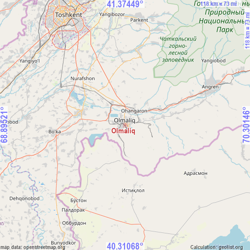
Olmaliq GPS coordinates[2]
40° 50' 40.992" North, 69° 35' 53.988" East
| Map corner | latitude | longitude |
|---|---|---|
| Upper-left | 41.37449°, | 68.89521° |
| Center: | 40.84472°, | 69.59833° |
| Lower-right: | 40.31068°, | 70.30146° |
| Map W x H: | 118.3×118.3 km | = 73.5×73.5mi |
| max Lat: | 43.77877° ⇑39.7% North |
| Olmaliq: | 40.84472° |
| min Lat: | ⇓60.3% South 37.22417° |
| min Long | Olmaliq | max Long |
| 58.84596° | 69.59833° | 72.76177° |
| W 64.9%⇐ | ⇒35.1% E |
Elevation
Elevation of Olmaliq is 569 m = 1867 ft, and this is 135.2 m = 444 ft above average elevation for this country.
| Max E: |
1464 m = 4803 ft | 22.4% |
| Olmaliq | 569 m 1867 ft | |
| Avg. | 433.8 m = 1423 ft | |
Min E: |
50 m = 164 ft | 77.6% |
See also: Olmaliq elevation on elevation.city.
Geographical zone
Olmaliq is located in North temperate zone (between Tropic of Cancer and the Arctic Circle). Distance of this Northern Tropic circle is 1935.6 km =1202.7 mi to South.| Distance of | km | miles | from Olmaliq |
|---|---|---|---|
| North Pole | 5465.6 | 3396.2 | to North |
| Arctic Circle | 2859.7 | 1776.9 | to North |
| Tropic Cancer | 1935.6 | 1202.7 | to South |
| Equator | 4541.5 | 2822 | to South |


Nearby cities:
15 places around Olmaliq: (largest is in red/bold)
• Amir Timur
58.5 km =36.4 mi,  289°
289°
• Angren
49.6 km =30.8 mi,  67°
67°
• Bektemir
46.2 km =28.7 mi,  331°
331°
• Bo‘ka
34.2 km =21.3 mi,  263°
263°
• Ohangaron
7.6 km =4.7 mi,  26°
26°
• Parkent
50.4 km =31.3 mi,  7°
7°
• Piskent
21.6 km =13.4 mi, 285°
• Salor
61.4 km =38.2 mi,  342°
342°
• Sŭqoq
47.9 km =29.8 mi,  20°
20°
• Tashkent
56.6 km =35.2 mi, 325°
• Tŭytepa
28.7 km =17.8 mi,  316°
316°
• Yangiobod
51.6 km =32.1 mi,  53°
53°
• Yangiyŭl
55 km =34.2 mi,  302°
302°
• Zafar
60.7 km =37.7 mi,  284°
284°
• Ŭrtaowul
53.8 km =33.4 mi, 315°
Sources, notices
• [Note1] Compared only with cities in Uzbekistan existing in our database
• [Src1] Map data: © OpenStreetMap contributors (CC-BY-SA)
• [Src2] Other city data from geonames.org with taken over terms of usage.
• [Src3] Geographical zone / Annual Mean Temperature by Robert A. Rohde @ Wikipedia
