Kyzyldzhar geodata
Kyzyldzhar (Toshkent) is a populated place; located in Uzbekistan in Asia/Tashkent (GMT+5) time zone. With population of 3,000 people, there are 112 cities with bigger population in this country. Compared to other cities in Uzbekistan, 86.2% of cities are located further ↓South; 68.4% of cities are located further ←West and 99.4% of cities have lower elevation than Kyzyldzhar. Note1


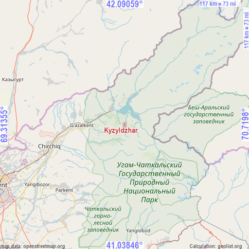
Kyzyldzhar GPS coordinates[2]
41° 34' 0.012" North, 70° 1' 0.012" East
| Map corner | latitude | longitude |
|---|---|---|
| Upper-left | 42.09059°, | 69.31355° |
| Center: | 41.56667°, | 70.01667° |
| Lower-right: | 41.03846°, | 70.7198° |
| Map W x H: | 117×117 km | = 72.7×72.7mi |
| max Lat: | 43.77877° ⇑13.8% North |
| Kyzyldzhar: | 41.56667° |
| min Lat: | ⇓86.2% South 37.22417° |
| min Long | Kyzyldzhar | max Long |
| 58.84596° | 70.01667° | 72.76177° |
| W 68.4%⇐ | ⇒31.6% E |
Elevation
Elevation of Kyzyldzhar is 1315 m = 4314 ft, and this is 881.2 m = 2891 ft above average elevation for this country.
| Max E: |
1464 m = 4803 ft | 0.59999999999999% |
| Kyzyldzhar | 1315 m 4314 ft | |
| Avg. | 433.8 m = 1423 ft | |
Min E: |
50 m = 164 ft | 99.4% |
See also: Uzbekistan elevation on elevation.city.
Geographical zone
Kyzyldzhar is located in North temperate zone (between Tropic of Cancer and the Arctic Circle). Distance of this Northern Tropic circle is 2015.9 km =1252.6 mi to South.| Distance of | km | miles | from Kyzyldzhar |
|---|---|---|---|
| North Pole | 5385.3 | 3346.3 | to North |
| Arctic Circle | 2779.4 | 1727 | to North |
| Tropic Cancer | 2015.9 | 1252.6 | to South |
| Equator | 4621.8 | 2871.9 | to South |


Nearby cities:
15 places around Kyzyldzhar: (largest is in red/bold)
• Angren
62.1 km =38.6 mi,  170°
170°
• Bektemir
69.4 km =43.1 mi,  235°
235°
• Chirchiq
37.8 km =23.5 mi,  253°
253°
• G‘azalkent
20.5 km =12.7 mi,  267°
267°
• Iskandar
26.3 km =16.3 mi, 266°
• Ohangaron
79.9 km =49.6 mi,  203°
203°
• Olmaliq
87.6 km =54.4 mi, 203°
• Parkent
41.5 km =25.8 mi,  223°
223°
• Qibray
50 km =31.1 mi, 246°
• Salor
57.2 km =35.5 mi, 247°
• Sŭqoq
39.8 km =24.7 mi,  207°
207°
• Tashkent
74.7 km =46.4 mi, 243°
• Tŭytepa
80.7 km =50.1 mi, 222°
• Yangiobod
50.2 km =31.2 mi, 172°
• Ŭrtaowul
84.1 km =52.3 mi, 239°
Sources, notices
• [Note1] Compared only with cities in Uzbekistan existing in our database
• [Src1] Map data: © OpenStreetMap contributors (CC-BY-SA)
• [Src2] Other city data from geonames.org with taken over terms of usage.
• [Src3] Geographical zone / Annual Mean Temperature by Robert A. Rohde @ Wikipedia
