Asaka geodata
Asaka (Andijon) is a seat of a second-order administrative division; located in Uzbekistan in Asia/Tashkent (GMT+5) time zone. With population of 56,736 people, there are 26 cities with bigger population in this country. Compared to other cities in Uzbekistan, 53.4% of cities are located further ↓South; 94.3% of cities are located further ←West and 67.2% of cities have lower elevation than Asaka. Note1


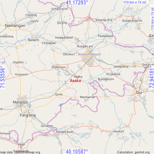
Asaka GPS coordinates[2]
40° 38' 29.508" North, 72° 14' 19.248" East
| Map corner | latitude | longitude |
|---|---|---|
| Upper-left | 41.17293°, | 71.53556° |
| Center: | 40.64153°, | 72.23868° |
| Lower-right: | 40.10587°, | 72.94181° |
| Map W x H: | 118.6×118.6 km | = 73.7×73.7mi |
| max Lat: | 43.77877° ⇑46.6% North |
| Asaka: | 40.64153° |
| min Lat: | ⇓53.4% South 37.22417° |
| min Long | Asaka | max Long |
| 58.84596° | 72.23868° | 72.76177° |
| W 94.3%⇐ | ⇒5.7% E |
Elevation
Elevation of Asaka is 501 m = 1644 ft, and this is 67.2 m = 220 ft above average elevation for this country.
| Max E: |
1464 m = 4803 ft | 32.8% |
| Asaka | 501 m 1644 ft | |
| Avg. | 433.8 m = 1423 ft | |
Min E: |
50 m = 164 ft | 67.2% |
See also: Asaka elevation on elevation.city.
Geographical zone
Asaka is located in North temperate zone (between Tropic of Cancer and the Arctic Circle). Distance of this Northern Tropic circle is 1913 km =1188.7 mi to South.| Distance of | km | miles | from Asaka |
|---|---|---|---|
| North Pole | 5488.1 | 3410.1 | to North |
| Arctic Circle | 2882.3 | 1791 | to North |
| Tropic Cancer | 1913 | 1188.7 | to South |
| Equator | 4518.9 | 2807.9 | to South |


Nearby cities:
15 places around Asaka: (largest is in red/bold)
• Andijon
18 km =11.2 mi,  29°
29°
• Buloqboshi
22.3 km =13.9 mi,  93°
93°
• Haqqulobod
32.3 km =20.1 mi,  341°
341°
• Kuyganyor
24.4 km =15.2 mi,  13°
13°
• Marhamat
17.2 km =10.7 mi,  154°
154°
• Marhamat
19 km =11.8 mi,  160°
160°
• Oltinko‘l
18.6 km =11.6 mi, 342°
• Oxunboboyev
35.2 km =21.9 mi,  75°
75°
• Paxtaobod
38.7 km =24 mi, 34°
• Poytug‘
28.5 km =17.7 mi,  1°
1°
• Quva
19.3 km =12 mi,  226°
226°
• Shahrixon
17.3 km =10.7 mi,  297°
297°
• Toshloq
43.8 km =27.2 mi,  245°
245°
• Xo‘jaobod
27.3 km =17 mi, 83°
• Yozyovon
41.8 km =26 mi,  273°
273°
Sources, notices
• [Note1] Compared only with cities in Uzbekistan existing in our database
• [Src1] Map data: © OpenStreetMap contributors (CC-BY-SA)
• [Src2] Other city data from geonames.org with taken over terms of usage.
• [Src3] Geographical zone / Annual Mean Temperature by Robert A. Rohde @ Wikipedia
