Marhamat geodata
Marhamat (Andijon) is a populated place; located in Uzbekistan in Asia/Tashkent (GMT+5) time zone. With population of 14,646 people, there are 95 cities with bigger population in this country. Compared to other cities in Uzbekistan, 54.6% of cities are located further ↑North; 96% of cities are located further ←West and 82.8% of cities have lower elevation than Marhamat. Note1


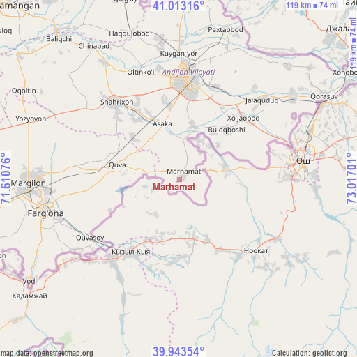
Marhamat GPS coordinates[2]
40° 28' 49.728" North, 72° 18' 49.968" East
| Map corner | latitude | longitude |
|---|---|---|
| Upper-left | 41.01316°, | 71.61076° |
| Center: | 40.48048°, | 72.31388° |
| Lower-right: | 39.94354°, | 73.01701° |
| Map W x H: | 118.9×118.9 km | = 73.9×73.9mi |
| max Lat: | 43.77877° ⇑54.6% North |
| Marhamat: | 40.48048° |
| min Lat: | ⇓45.4% South 37.22417° |
| min Long | Marhamat | max Long |
| 58.84596° | 72.31388° | 72.76177° |
| W 96%⇐ | ⇒4% E |
Elevation
Elevation of Marhamat is 627 m = 2057 ft, and this is 193.2 m = 634 ft above average elevation for this country.
| Max E: |
1464 m = 4803 ft | 17.2% |
| Marhamat | 627 m 2057 ft | |
| Avg. | 433.8 m = 1423 ft | |
Min E: |
50 m = 164 ft | 82.8% |
See also: Uzbekistan elevation on elevation.city.
Geographical zone
Marhamat is located in North temperate zone (between Tropic of Cancer and the Arctic Circle). Distance of this Northern Tropic circle is 1895.1 km =1177.6 mi to South.| Distance of | km | miles | from Marhamat |
|---|---|---|---|
| North Pole | 5506.1 | 3421.3 | to North |
| Arctic Circle | 2900.2 | 1802.1 | to North |
| Tropic Cancer | 1895.1 | 1177.6 | to South |
| Equator | 4501 | 2796.8 | to South |


Nearby cities:
15 places around Marhamat: (largest is in red/bold)
• Andijon
33.6 km =20.9 mi,  4°
4°
• Asaka
19 km =11.8 mi,  340°
340°
• Buloqboshi
22.9 km =14.2 mi,  43°
43°
• Fergana
46.1 km =28.6 mi,  256°
256°
• Kirguli
46.5 km =28.9 mi, 263°
• Kuyganyor
41.6 km =25.8 mi,  359°
359°
• Marhamat
2.7 km =1.7 mi,  23°
23°
• Oltinko‘l
37.6 km =23.4 mi, 341°
• Oxunboboyev
38.5 km =23.9 mi,  46°
46°
• Poytug‘
46.8 km =29.1 mi,  352°
352°
• Quva
20.9 km =13 mi,  282°
282°
• Quvasoy
34.8 km =21.6 mi,  234°
234°
• Shahrixon
33.8 km =21 mi,  320°
320°
• Toshloq
46.2 km =28.7 mi,  269°
269°
• Xo‘jaobod
29.5 km =18.3 mi, 44°
Sources, notices
• [Note1] Compared only with cities in Uzbekistan existing in our database
• [Src1] Map data: © OpenStreetMap contributors (CC-BY-SA)
• [Src2] Other city data from geonames.org with taken over terms of usage.
• [Src3] Geographical zone / Annual Mean Temperature by Robert A. Rohde @ Wikipedia
