El Vigía geodata
El Vigía (Mérida) is a seat of a second-order administrative division; located in Venezuela in America/Caracas (GMT-4) time zone. With population of 59,092 people, there are 63 cities with bigger population in this country. Compared to other cities in Venezuela, 71.8% of cities are located further ↑North; 88.8% of cities are located further →East and 54.5% of cities have higher elevation than El Vigía. Note1


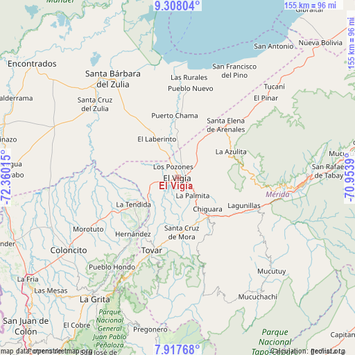
El Vigía GPS coordinates[2]
8° 36' 48.6" North, 71° 39' 25.272" West
| Map corner | latitude | longitude |
|---|---|---|
| Upper-left | 9.30804°, | -72.36015° |
| Center: | 8.6135°, | -71.65702° |
| Lower-right: | 7.91768°, | -70.9539° |
| Map W x H: | 154.6×154.6 km | = 96.1×96.1mi |
| max Lat: | 11.94788° ⇑71.8% North |
| El Vigía: | 8.6135° |
| min Lat: | ⇓28.2% South 1.92027° |
| min Long | El Vigía | max Long |
| -72.55212° | -71.65702° | -60.99778° |
| W 11.2%⇐ | ⇒88.8% E |
Elevation
Elevation of El Vigía is 161 m = 528 ft, and this is 219.6 m = 720 ft below average elevation for this country.
| Max E: |
2986 m = 9797 ft | 54.5% |
| Avg. | 380.6 m = 1249 ft | |
| El Vigía | 161 m = 528 ft | |
Min E: |
-4 m = -13 ft | 45.5% |
See also: El Vigía elevation on elevation.city.
Geographical zone
El Vigía is located in North Torrid zone (between Equator and Tropic of Cancer). Distance of Equator is 957.7 km =595.1 mi to South.| Distance of | km | miles | from El Vigía |
|---|---|---|---|
| North Pole | 9049.3 | 5623 | to North |
| Arctic Circle | 6443.4 | 4003.7 | to North |
| Tropic Cancer | 1648.2 | 1024.1 | to North |
| Equator | 957.7 | 595.1 | to South |


Nearby cities:
15 places around El Vigía: (largest is in red/bold)
• Bailadores
44.2 km =27.5 mi,  205°
205°
• Coloncito
57.1 km =35.5 mi,  235°
235°
• Ejido
46.4 km =28.8 mi,  99°
99°
• Guaraque
51.8 km =32.2 mi,  189°
189°
• La Azulita
25.9 km =16.1 mi,  64°
64°
• La Tendida
22.6 km =14 mi, 238°
• Lagunillas
31.8 km =19.8 mi,  112°
112°
• Mérida
55.1 km =34.2 mi,  92°
92°
• Pueblo Nuevo El Chivo
39.2 km =24.4 mi,  7°
7°
• San Carlos del Zulia
52.3 km =32.5 mi,  325°
325°
• San Simón
36.2 km =22.5 mi,  216°
216°
• Santa Cruz de Mora
23.9 km =14.9 mi,  175°
175°
• Santa Elena de Arenales
31.2 km =19.4 mi,  42°
42°
• Tovar
33.2 km =20.6 mi,  198°
198°
• Zea
29.8 km =18.5 mi, 207°
Sources, notices
• [Note1] Compared only with cities in Venezuela existing in our database
• [Src1] Map data: © OpenStreetMap contributors (CC-BY-SA)
• [Src2] Other city data from geonames.org with taken over terms of usage.
• [Src3] Geographical zone / Annual Mean Temperature by Robert A. Rohde @ Wikipedia
