Tumeremo geodata
Tumeremo (Bolívar) is a seat of a second-order administrative division; located in Venezuela in America/Caracas (GMT-4) time zone. In our database, there are 108 cities with bigger population. Compared to other cities in Venezuela, 97.5% of cities are located further ↑North; 99.5% of cities are located further ←West and 51.4% of cities have higher elevation than Tumeremo. Note1


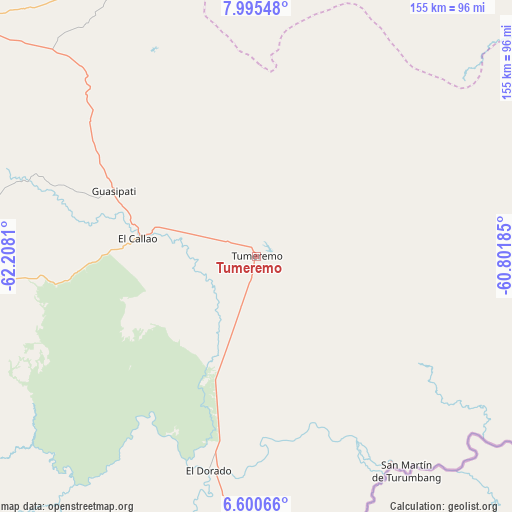
Tumeremo GPS coordinates[2]
7° 17' 54.996" North, 61° 30' 17.892" West
| Map corner | latitude | longitude |
|---|---|---|
| Upper-left | 7.99548°, | -62.2081° |
| Center: | 7.29861°, | -61.50497° |
| Lower-right: | 6.60066°, | -60.80185° |
| Map W x H: | 155.1×155.1 km | = 96.4×96.4mi |
| max Lat: | 11.94788° ⇑97.5% North |
| Tumeremo: | 7.29861° |
| min Lat: | ⇓2.5% South 1.92027° |
| min Long | Tumeremo | max Long |
| -72.55212° | -61.50497° | -60.99778° |
| W 99.5%⇐ | ⇒0.5% E |
Elevation
Elevation of Tumeremo is 175 m = 574 ft, and this is 205.6 m = 675 ft below average elevation for this country.
| Max E: |
2986 m = 9797 ft | 51.4% |
| Avg. | 380.6 m = 1249 ft | |
| Tumeremo | 175 m = 574 ft | |
Min E: |
-4 m = -13 ft | 48.6% |
See also: Venezuela elevation on elevation.city.
Geographical zone
Tumeremo is located in North Torrid zone (between Equator and Tropic of Cancer). Distance of Equator is 811.5 km =504.2 mi to South.| Distance of | km | miles | from Tumeremo |
|---|---|---|---|
| North Pole | 9195.5 | 5713.8 | to North |
| Arctic Circle | 6589.6 | 4094.6 | to North |
| Tropic Cancer | 1794.4 | 1115 | to North |
| Equator | 811.5 | 504.2 | to South |


Nearby cities:
15 places around Tumeremo: (largest is in red/bold)
• Barrancas
173.3 km =107.7 mi,  333°
333°
• Ciudad Bolívar
242.6 km =150.7 mi,  292°
292°
• Ciudad Guayana
171.3 km =106.4 mi,  313°
313°
• Ciudad Piar
200.9 km =124.8 mi,  274°
274°
• Curiapo
153.1 km =95.1 mi,  21°
21°
• El Callao
35.9 km =22.3 mi,  278°
278°
• El Palmar
90.7 km =56.4 mi, 330°
• El Palmer
91.7 km =57 mi, 332°
• Guasipati
47.5 km =29.5 mi, 294°
• Sierra Imataca
160.5 km =99.7 mi,  319°
319°
• Soledad
246.5 km =153.2 mi, 292°
• Temblador
227.5 km =141.4 mi, 326°
• Tucupita
204.6 km =127.1 mi,  342°
342°
• Upata
127.3 km =79.1 mi, 308°
• Uracoa
210.3 km =130.7 mi, 333°
Sources, notices
• [Note1] Compared only with cities in Venezuela existing in our database
• [Src1] Map data: © OpenStreetMap contributors (CC-BY-SA)
• [Src2] Other city data from geonames.org with taken over terms of usage.
• [Src3] Geographical zone / Annual Mean Temperature by Robert A. Rohde @ Wikipedia
