Guasipati geodata
Guasipati (Bolívar) is a seat of a second-order administrative division; located in Venezuela in America/Caracas (GMT-4) time zone. In our database, there are 108 cities with bigger population. Compared to other cities in Venezuela, 96.2% of cities are located further ↑North; 98.7% of cities are located further ←West and 53.9% of cities have lower elevation than Guasipati. Note1


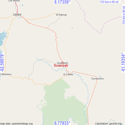
Guasipati GPS coordinates[2]
7° 28' 37.272" North, 61° 53' 47.976" West
| Map corner | latitude | longitude |
|---|---|---|
| Upper-left | 8.17359°, | -62.59979° |
| Center: | 7.47702°, | -61.89666° |
| Lower-right: | 6.77933°, | -61.19354° |
| Map W x H: | 155×155 km | = 96.3×96.3mi |
| max Lat: | 11.94788° ⇑96.2% North |
| Guasipati: | 7.47702° |
| min Lat: | ⇓3.8% South 1.92027° |
| min Long | Guasipati | max Long |
| -72.55212° | -61.89666° | -60.99778° |
| W 98.7%⇐ | ⇒1.3% E |
Elevation
Elevation of Guasipati is 198 m = 650 ft, and this is 182.6 m = 599 ft below average elevation for this country.
| Max E: |
2986 m = 9797 ft | 46.1% |
| Avg. | 380.6 m = 1249 ft | |
| Guasipati | 198 m = 650 ft | |
Min E: |
-4 m = -13 ft | 53.9% |
See also: Venezuela elevation on elevation.city.
Geographical zone
Guasipati is located in North Torrid zone (between Equator and Tropic of Cancer). Distance of Equator is 831.4 km =516.6 mi to South.| Distance of | km | miles | from Guasipati |
|---|---|---|---|
| North Pole | 9175.7 | 5701.5 | to North |
| Arctic Circle | 6569.8 | 4082.3 | to North |
| Tropic Cancer | 1774.6 | 1102.7 | to North |
| Equator | 831.4 | 516.6 | to South |


Nearby cities:
15 places around Guasipati: (largest is in red/bold)
• Barrancas
139.8 km =86.9 mi,  346°
346°
• Ciudad Bolívar
195.1 km =121.2 mi,  291°
291°
• Ciudad Guayana
127.2 km =79 mi,  319°
319°
• Ciudad Piar
156.9 km =97.5 mi,  268°
268°
• Curiapo
157.6 km =97.9 mi,  38°
38°
• El Callao
16.4 km =10.2 mi,  151°
151°
• El Palmar
59.4 km =36.9 mi,  358°
358°
• El Palmer
61.9 km =38.5 mi,  1°
1°
• Sierra Imataca
119 km =73.9 mi,  328°
328°
• Soledad
199 km =123.7 mi, 292°
• Temblador
188.8 km =117.3 mi, 334°
• Tucupita
176.6 km =109.7 mi, 354°
• Tumeremo
47.5 km =29.5 mi,  114°
114°
• Upata
82.1 km =51 mi, 316°
• Uracoa
176 km =109.4 mi,  343°
343°
Sources, notices
• [Note1] Compared only with cities in Venezuela existing in our database
• [Src1] Map data: © OpenStreetMap contributors (CC-BY-SA)
• [Src2] Other city data from geonames.org with taken over terms of usage.
• [Src3] Geographical zone / Annual Mean Temperature by Robert A. Rohde @ Wikipedia
