El Callao geodata
El Callao (Bolívar) is a seat of a second-order administrative division; located in Venezuela in America/Caracas (GMT-4) time zone. In our database, there are 108 cities with bigger population. Compared to other cities in Venezuela, 97.2% of cities are located further ↑North; 99.2% of cities are located further ←West and 52.2% of cities have higher elevation than El Callao. Note1


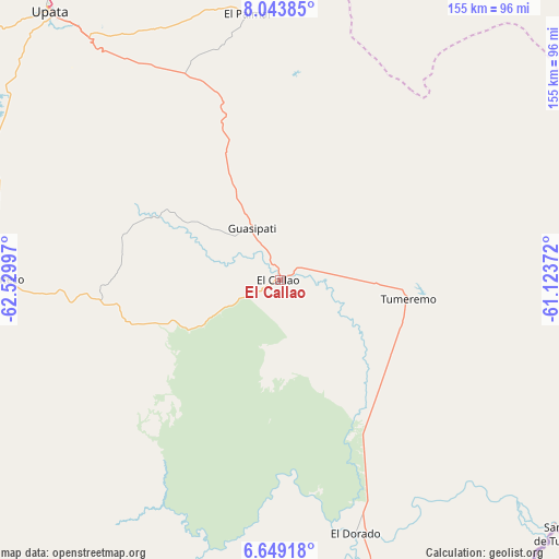
El Callao GPS coordinates[2]
7° 20' 49.416" North, 61° 49' 36.624" West
| Map corner | latitude | longitude |
|---|---|---|
| Upper-left | 8.04385°, | -62.52997° |
| Center: | 7.34706°, | -61.82684° |
| Lower-right: | 6.64918°, | -61.12372° |
| Map W x H: | 155.1×155.1 km | = 96.4×96.4mi |
| max Lat: | 11.94788° ⇑97.2% North |
| El Callao: | 7.34706° |
| min Lat: | ⇓2.8% South 1.92027° |
| min Long | El Callao | max Long |
| -72.55212° | -61.82684° | -60.99778° |
| W 99.2%⇐ | ⇒0.8% E |
Elevation
Elevation of El Callao is 171 m = 561 ft, and this is 209.6 m = 688 ft below average elevation for this country.
| Max E: |
2986 m = 9797 ft | 52.2% |
| Avg. | 380.6 m = 1249 ft | |
| El Callao | 171 m = 561 ft | |
Min E: |
-4 m = -13 ft | 47.8% |
See also: Venezuela elevation on elevation.city.
Geographical zone
El Callao is located in North Torrid zone (between Equator and Tropic of Cancer). Distance of Equator is 816.9 km =507.6 mi to South.| Distance of | km | miles | from El Callao |
|---|---|---|---|
| North Pole | 9190.1 | 5710.5 | to North |
| Arctic Circle | 6584.3 | 4091.3 | to North |
| Tropic Cancer | 1789 | 1111.6 | to North |
| Equator | 816.9 | 507.6 | to South |


Nearby cities:
15 places around El Callao: (largest is in red/bold)
• Barrancas
155.7 km =96.7 mi,  344°
344°
• Ciudad Bolívar
207.9 km =129.2 mi,  294°
294°
• Ciudad Guayana
143.2 km =89 mi,  321°
321°
• Ciudad Piar
165 km =102.5 mi,  274°
274°
• Curiapo
164.8 km =102.4 mi,  33°
33°
• El Palmar
74.3 km =46.2 mi,  353°
353°
• El Palmer
76.6 km =47.6 mi,  355°
355°
• Guasipati
16.4 km =10.2 mi,  331°
331°
• Sierra Imataca
135.3 km =84.1 mi, 329°
• Soledad
211.9 km =131.7 mi,  295°
295°
• Temblador
205.2 km =127.5 mi, 333°
• Tucupita
191.8 km =119.2 mi, 352°
• Tumeremo
35.9 km =22.3 mi,  98°
98°
• Upata
98 km =60.9 mi, 319°
• Uracoa
192.1 km =119.4 mi, 342°
Sources, notices
• [Note1] Compared only with cities in Venezuela existing in our database
• [Src1] Map data: © OpenStreetMap contributors (CC-BY-SA)
• [Src2] Other city data from geonames.org with taken over terms of usage.
• [Src3] Geographical zone / Annual Mean Temperature by Robert A. Rohde @ Wikipedia
