Ureña geodata
Ureña (Táchira) is a seat of a second-order administrative division; located in Venezuela in America/Caracas (GMT-4) time zone. In our database, there are 108 cities with bigger population. Compared to other cities in Venezuela, 88.8% of cities are located further ↑North; 99.2% of cities are located further →East and 66.9% of cities have lower elevation than Ureña. Note1


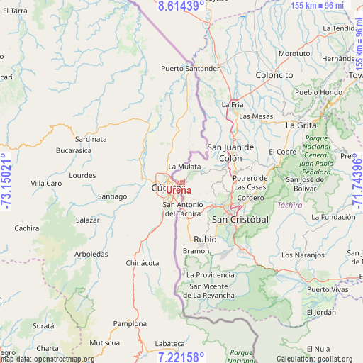
Ureña GPS coordinates[2]
7° 55' 6.852" North, 72° 26' 49.488" West
| Map corner | latitude | longitude |
|---|---|---|
| Upper-left | 8.61439°, | -73.15021° |
| Center: | 7.91857°, | -72.44708° |
| Lower-right: | 7.22158°, | -71.74396° |
| Map W x H: | 154.9×154.9 km | = 96.3×96.3mi |
| max Lat: | 11.94788° ⇑88.8% North |
| Ureña: | 7.91857° |
| min Lat: | ⇓11.2% South 1.92027° |
| min Long | Ureña | max Long |
| -72.55212° | -72.44708° | -60.99778° |
| W 0.8%⇐ | ⇒99.2% E |
Elevation
Elevation of Ureña is 345 m = 1132 ft, and this is 35.6 m = 117 ft below average elevation for this country.
| Max E: |
2986 m = 9797 ft | 33.1% |
| Avg. | 380.6 m = 1249 ft | |
| Ureña | 345 m = 1132 ft | |
Min E: |
-4 m = -13 ft | 66.9% |
See also: Venezuela elevation on elevation.city.
Geographical zone
Ureña is located in North Torrid zone (between Equator and Tropic of Cancer). Distance of Equator is 880.5 km =547.1 mi to South.| Distance of | km | miles | from Ureña |
|---|---|---|---|
| North Pole | 9126.6 | 5671 | to North |
| Arctic Circle | 6520.7 | 4051.8 | to North |
| Tropic Cancer | 1725.5 | 1072.2 | to North |
| Equator | 880.5 | 547.1 | to South |


Nearby cities:
15 places around Ureña: (largest is in red/bold)
• Capacho Nuevo
18.5 km =11.5 mi,  124°
124°
• Capacho Viejo
17.2 km =10.7 mi,  125°
125°
• Colón
24.1 km =15 mi,  58°
58°
• Cordero
30.1 km =18.7 mi,  103°
103°
• Delicias
39.3 km =24.4 mi,  180°
180°
• La Fría
39.5 km =24.5 mi,  33°
33°
• Lobatera
22 km =13.7 mi,  86°
86°
• Michelena
22.9 km =14.2 mi,  79°
79°
• Palmira
25.8 km =16 mi,  110°
110°
• Rubio
26.2 km =16.3 mi,  157°
157°
• San Antonio del Táchira
11.6 km =7.2 mi, 177°
• San Cristóbal
29.7 km =18.5 mi, 124°
• San Josecito
38 km =23.6 mi,  138°
138°
• Santa Ana
36 km =22.4 mi,  148°
148°
• Táriba
26.9 km =16.7 mi, 114°
Sources, notices
• [Note1] Compared only with cities in Venezuela existing in our database
• [Src1] Map data: © OpenStreetMap contributors (CC-BY-SA)
• [Src2] Other city data from geonames.org with taken over terms of usage.
• [Src3] Geographical zone / Annual Mean Temperature by Robert A. Rohde @ Wikipedia
