Tucacas geodata
Tucacas (Falcón) is a seat of a second-order administrative division; located in Venezuela in America/Caracas (GMT-4) time zone. With population of 12,500 people, there are 106 cities with bigger population in this country. Compared to other cities in Venezuela, 90.8% of cities are located further ↓South; 55.5% of cities are located further ←West and 96.4% of cities have higher elevation than Tucacas. Note1


Tucacas GPS coordinates[2]
10° 47' 24.216" North, 68° 19' 32.304" West
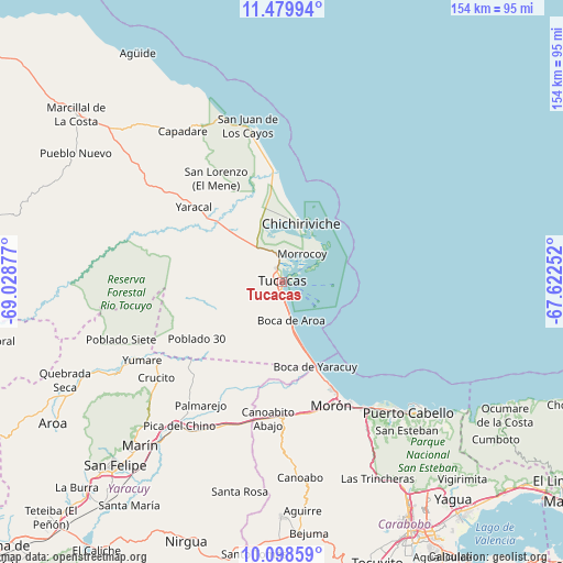
| Map corner | latitude | longitude |
|---|---|---|
| Upper-left | 11.47994°, | -69.02877° |
| Center: | 10.79006°, | -68.32564° |
| Lower-right: | 10.09859°, | -67.62252° |
| Map W x H: | 153.6×153.6 km | = 95.4×95.4mi |
| max Lat: | 11.94788° ⇑9.2% North |
| Tucacas: | 10.79006° |
| min Lat: | ⇓90.8% South 1.92027° |
| min Long | Tucacas | max Long |
| -72.55212° | -68.32564° | -60.99778° |
| W 55.5%⇐ | ⇒44.5% E |
Elevation
Elevation of Tucacas is 3 m = 10 ft, and this is 377.6 m = 1239 ft below average elevation for this country.
| Max E: |
2986 m = 9797 ft | 96.4% |
| Avg. | 380.6 m = 1249 ft | |
| Tucacas | 3 m = 10 ft | |
Min E: |
-4 m = -13 ft | 3.6% |
See also: Venezuela elevation on elevation.city.
Geographical zone
Tucacas is located in North Torrid zone (between Equator and Tropic of Cancer). Distance of Equator is 1199.7 km =745.5 mi to South.| Distance of | km | miles | from Tucacas |
|---|---|---|---|
| North Pole | 8807.3 | 5472.6 | to North |
| Arctic Circle | 6201.4 | 3853.4 | to North |
| Tropic Cancer | 1406.2 | 873.8 | to North |
| Equator | 1199.7 | 745.5 | to South |


Nearby cities:
15 places around Tucacas: (largest is in red/bold)
• Bejuma
68.9 km =42.8 mi,  173°
173°
• Chichiriviche
16.5 km =10.3 mi,  20°
20°
• Farriar
43.8 km =27.2 mi,  215°
215°
• Independencia
69.1 km =42.9 mi, 222°
• Jacura
66 km =41 mi,  298°
298°
• Mirimire
60 km =37.3 mi,  313°
313°
• Montalbán
64.1 km =39.8 mi,  180°
180°
• Morón
36.3 km =22.6 mi,  157°
157°
• Naguanagua
68.3 km =42.4 mi,  150°
150°
• Palmasola
32.4 km =20.1 mi,  227°
227°
• Puerto Cabello
49.1 km =30.5 mi,  135°
135°
• San Felipe
67.7 km =42.1 mi, 222°
• San Juan de los Cayos
43.5 km =27 mi,  347°
347°
• Yaracal
31.3 km =19.4 mi, 309°
• Yumare
43.6 km =27.1 mi,  240°
240°
Sources, notices
• [Note1] Compared only with cities in Venezuela existing in our database
• [Src1] Map data: © OpenStreetMap contributors (CC-BY-SA)
• [Src2] Other city data from geonames.org with taken over terms of usage.
• [Src3] Geographical zone / Annual Mean Temperature by Robert A. Rohde @ Wikipedia
