Pedernales geodata
Pedernales (Delta Amacuro) is a seat of a second-order administrative division; located in Venezuela in America/Caracas (GMT-4) time zone. In our database, there are 108 cities with bigger population. Compared to other cities in Venezuela, 58% of cities are located further ↓South; 97.7% of cities are located further ←West and 90.3% of cities have higher elevation than Pedernales. Note1


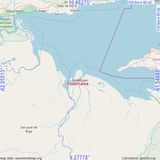
Pedernales GPS coordinates[2]
9° 58' 15.6" North, 62° 15' 7.2" West
| Map corner | latitude | longitude |
|---|---|---|
| Upper-left | 10.66275°, | -62.95513° |
| Center: | 9.971°, | -62.252° |
| Lower-right: | 9.27778°, | -61.54888° |
| Map W x H: | 154×154 km | = 95.7×95.7mi |
| max Lat: | 11.94788° ⇑42% North |
| Pedernales: | 9.971° |
| min Lat: | ⇓58% South 1.92027° |
| min Long | Pedernales | max Long |
| -72.55212° | -62.252° | -60.99778° |
| W 97.7%⇐ | ⇒2.3% E |
Elevation
Elevation of Pedernales is 13 m = 43 ft, and this is 367.6 m = 1206 ft below average elevation for this country.
| Max E: |
2986 m = 9797 ft | 90.3% |
| Avg. | 380.6 m = 1249 ft | |
| Pedernales | 13 m = 43 ft | |
Min E: |
-4 m = -13 ft | 9.7% |
See also: Venezuela elevation on elevation.city.
Geographical zone
Pedernales is located in North Torrid zone (between Equator and Tropic of Cancer). Distance of Equator is 1108.7 km =688.9 mi to South.| Distance of | km | miles | from Pedernales |
|---|---|---|---|
| North Pole | 8898.4 | 5529.2 | to North |
| Arctic Circle | 6292.5 | 3910 | to North |
| Tropic Cancer | 1497.2 | 930.3 | to North |
| Equator | 1108.7 | 688.9 | to South |


Nearby cities:
15 places around Pedernales: (largest is in red/bold)
• Aragua
135.3 km =84.1 mi,  269°
269°
• Caripito
94.1 km =58.5 mi,  279°
279°
• Carúpano
134 km =83.3 mi,  305°
305°
• El Pilar
117.7 km =73.1 mi,  303°
303°
• Güiria
67.6 km =42 mi,  355°
355°
• Irapa
75.8 km =47.1 mi,  331°
331°
• Maturín
105 km =65.2 mi,  256°
256°
• Quiriquire
106 km =65.9 mi, 270°
• Río Caribe
123.7 km =76.9 mi, 310°
• San José de Aerocuar
137 km =85.1 mi, 300°
• Temblador
115.7 km =71.9 mi,  201°
201°
• Tucupita
103.9 km =64.6 mi,  167°
167°
• Tunapuy
115.2 km =71.6 mi, 305°
• Uracoa
109.1 km =67.8 mi,  185°
185°
• Yaguaraparo
91.4 km =56.8 mi,  316°
316°
Sources, notices
• [Note1] Compared only with cities in Venezuela existing in our database
• [Src1] Map data: © OpenStreetMap contributors (CC-BY-SA)
• [Src2] Other city data from geonames.org with taken over terms of usage.
• [Src3] Geographical zone / Annual Mean Temperature by Robert A. Rohde @ Wikipedia
