Güiria geodata
Güiria (Sucre) is a seat of a second-order administrative division; located in Venezuela in America/Caracas (GMT-4) time zone. With population of 40,000 people, there are 86 cities with bigger population in this country. Compared to other cities in Venezuela, 86% of cities are located further ↓South; 97.5% of cities are located further ←West and 91.3% of cities have higher elevation than Güiria. Note1


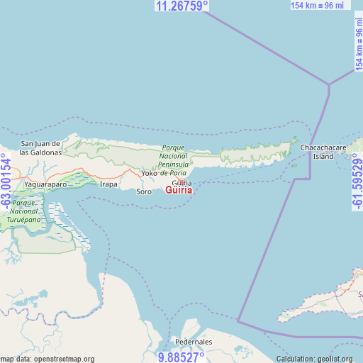
Güiria GPS coordinates[2]
10° 34' 37.956" North, 62° 17' 54.276" West
| Map corner | latitude | longitude |
|---|---|---|
| Upper-left | 11.26759°, | -63.00154° |
| Center: | 10.57721°, | -62.29841° |
| Lower-right: | 9.88527°, | -61.59529° |
| Map W x H: | 153.7×153.7 km | = 95.5×95.5mi |
| max Lat: | 11.94788° ⇑14% North |
| Güiria: | 10.57721° |
| min Lat: | ⇓86% South 1.92027° |
| min Long | Güiria | max Long |
| -72.55212° | -62.29841° | -60.99778° |
| W 97.5%⇐ | ⇒2.5% E |
Elevation
Elevation of Güiria is 10 m = 33 ft, and this is 370.6 m = 1216 ft below average elevation for this country.
| Max E: |
2986 m = 9797 ft | 91.3% |
| Avg. | 380.6 m = 1249 ft | |
| Güiria | 10 m = 33 ft | |
Min E: |
-4 m = -13 ft | 8.7% |
See also: Güiria elevation on elevation.city.
Geographical zone
Güiria is located in North Torrid zone (between Equator and Tropic of Cancer). Distance of Equator is 1176.1 km =730.8 mi to South.| Distance of | km | miles | from Güiria |
|---|---|---|---|
| North Pole | 8831 | 5487.3 | to North |
| Arctic Circle | 6225.1 | 3868.1 | to North |
| Tropic Cancer | 1429.8 | 888.4 | to North |
| Equator | 1176.1 | 730.8 | to South |


Nearby cities:
15 places around Güiria: (largest is in red/bold)
• Aragua
146.5 km =91 mi,  242°
242°
• Cariaco
137.4 km =85.4 mi,  266°
266°
• Caripe
138.9 km =86.3 mi,  251°
251°
• Caripito
101.8 km =63.3 mi, 239°
• Carúpano
104.9 km =65.2 mi,  275°
275°
• Casanay
122.6 km =76.2 mi, 266°
• El Pilar
93.6 km =58.2 mi, 267°
• Irapa
31 km =19.3 mi, 268°
• Maturín
133.9 km =83.2 mi,  226°
226°
• Pedernales
67.6 km =42 mi,  175°
175°
• Quiriquire
120.8 km =75.1 mi, 236°
• Río Caribe
89.6 km =55.7 mi, 278°
• San José de Aerocuar
112.6 km =70 mi, 271°
• Tunapuy
88.4 km =54.9 mi, 269°
• Yaguaraparo
57.7 km =35.9 mi, 269°
Sources, notices
• [Note1] Compared only with cities in Venezuela existing in our database
• [Src1] Map data: © OpenStreetMap contributors (CC-BY-SA)
• [Src2] Other city data from geonames.org with taken over terms of usage.
• [Src3] Geographical zone / Annual Mean Temperature by Robert A. Rohde @ Wikipedia
