Papelón geodata
Papelón (Portuguesa) is a seat of a second-order administrative division; located in Venezuela in America/Caracas (GMT-4) time zone. In our database, there are 108 cities with bigger population. Compared to other cities in Venezuela, 64.9% of cities are located further ↑North; 58.3% of cities are located further →East and 64.6% of cities have higher elevation than Papelón. Note1


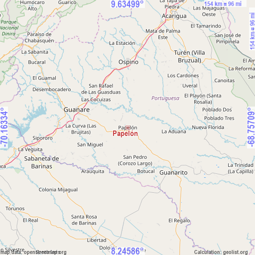
Papelón GPS coordinates[2]
8° 56' 27.924" North, 69° 27' 36.756" West
| Map corner | latitude | longitude |
|---|---|---|
| Upper-left | 9.63499°, | -70.16334° |
| Center: | 8.94109°, | -69.46021° |
| Lower-right: | 8.24586°, | -68.75709° |
| Map W x H: | 154.5×154.5 km | = 96×96mi |
| max Lat: | 11.94788° ⇑64.9% North |
| Papelón: | 8.94109° |
| min Lat: | ⇓35.1% South 1.92027° |
| min Long | Papelón | max Long |
| -72.55212° | -69.46021° | -60.99778° |
| W 41.7%⇐ | ⇒58.3% E |
Elevation
Elevation of Papelón is 109 m = 358 ft, and this is 271.6 m = 891 ft below average elevation for this country.
| Max E: |
2986 m = 9797 ft | 64.6% |
| Avg. | 380.6 m = 1249 ft | |
| Papelón | 109 m = 358 ft | |
Min E: |
-4 m = -13 ft | 35.4% |
See also: Venezuela elevation on elevation.city.
Geographical zone
Papelón is located in North Torrid zone (between Equator and Tropic of Cancer). Distance of Equator is 994.2 km =617.8 mi to South.| Distance of | km | miles | from Papelón |
|---|---|---|---|
| North Pole | 9012.9 | 5600.4 | to North |
| Arctic Circle | 6407 | 3981.1 | to North |
| Tropic Cancer | 1611.8 | 1001.5 | to North |
| Equator | 994.2 | 617.8 | to South |


Nearby cities:
15 places around Papelón: (largest is in red/bold)
• Arauquita
33.7 km =20.9 mi,  219°
219°
• Boconoito
58.1 km =36.1 mi,  259°
259°
• Dolores
73.7 km =45.8 mi,  189°
189°
• El Playón
48.9 km =30.4 mi,  68°
68°
• El Regalo
64.4 km =40 mi,  151°
151°
• Guanare
32.9 km =20.4 mi,  289°
289°
• Guanarito
38.8 km =24.1 mi,  134°
134°
• La Luz
72.8 km =45.2 mi,  213°
213°
• Libertad
70.8 km =44 mi,  195°
195°
• Ospino
39.4 km =24.5 mi,  0°
0°
• Píritu
55.1 km =34.2 mi,  29°
29°
• Sabaneta
56.1 km =34.9 mi,  248°
248°
• Santa Rosa
61.7 km =38.3 mi, 205°
• Veguitas
60.3 km =37.5 mi, 257°
• Villa Bruzual
57.3 km =35.6 mi,  40°
40°
Sources, notices
• [Note1] Compared only with cities in Venezuela existing in our database
• [Src1] Map data: © OpenStreetMap contributors (CC-BY-SA)
• [Src2] Other city data from geonames.org with taken over terms of usage.
• [Src3] Geographical zone / Annual Mean Temperature by Robert A. Rohde @ Wikipedia
