El Pao geodata
El Pao (Cojedes) is a seat of a second-order administrative division; located in Venezuela in America/Caracas (GMT-4) time zone. In our database, there are 108 cities with bigger population. Compared to other cities in Venezuela, 51.4% of cities are located further ↓South; 57.3% of cities are located further ←West and 59.5% of cities have higher elevation than El Pao. Note1


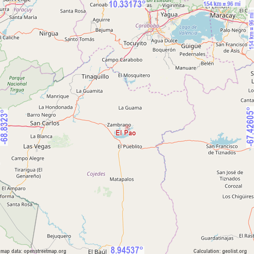
El Pao GPS coordinates[2]
9° 38' 21.336" North, 68° 7' 45.012" West
| Map corner | latitude | longitude |
|---|---|---|
| Upper-left | 10.33173°, | -68.8323° |
| Center: | 9.63926°, | -68.12917° |
| Lower-right: | 8.94537°, | -67.42605° |
| Map W x H: | 154.1×154.2 km | = 95.8×95.8mi |
| max Lat: | 11.94788° ⇑48.6% North |
| El Pao: | 9.63926° |
| min Lat: | ⇓51.4% South 1.92027° |
| min Long | El Pao | max Long |
| -72.55212° | -68.12917° | -60.99778° |
| W 57.3%⇐ | ⇒42.7% E |
Elevation
Elevation of El Pao is 136 m = 446 ft, and this is 244.6 m = 802 ft below average elevation for this country.
| Max E: |
2986 m = 9797 ft | 59.5% |
| Avg. | 380.6 m = 1249 ft | |
| El Pao | 136 m = 446 ft | |
Min E: |
-4 m = -13 ft | 40.5% |
See also: Venezuela elevation on elevation.city.
Geographical zone
El Pao is located in North Torrid zone (between Equator and Tropic of Cancer). Distance of Equator is 1071.8 km =666 mi to South.| Distance of | km | miles | from El Pao |
|---|---|---|---|
| North Pole | 8935.3 | 5552.1 | to North |
| Arctic Circle | 6329.4 | 3932.9 | to North |
| Tropic Cancer | 1534.1 | 953.2 | to North |
| Equator | 1071.8 | 666 | to South |


Nearby cities:
15 places around El Pao: (largest is in red/bold)
• Bejuma
61.1 km =38 mi,  346°
346°
• Güigüe
62.6 km =38.9 mi,  37°
37°
• Las Vegas
56.1 km =34.9 mi,  258°
258°
• Libertad
69.3 km =43.1 mi,  243°
243°
• Los Guayos
64.6 km =40.1 mi,  18°
18°
• Macapo
39.7 km =24.7 mi,  301°
301°
• Miranda
63.8 km =39.6 mi,  333°
333°
• Montalbán
67.4 km =41.9 mi,  341°
341°
• Naguanagua
69.7 km =43.3 mi,  10°
10°
• San Carlos
49.8 km =30.9 mi,  272°
272°
• Tacarigua
54.7 km =34 mi, 24°
• Tinaco
33.9 km =21.1 mi,  281°
281°
• Tinaquillo
36.5 km =22.7 mi, 328°
• Tocuyito
53.2 km =33.1 mi, 7°
• Valencia
59.6 km =37 mi, 12°
Sources, notices
• [Note1] Compared only with cities in Venezuela existing in our database
• [Src1] Map data: © OpenStreetMap contributors (CC-BY-SA)
• [Src2] Other city data from geonames.org with taken over terms of usage.
• [Src3] Geographical zone / Annual Mean Temperature by Robert A. Rohde @ Wikipedia
