Tinaco geodata
Tinaco (Cojedes) is a seat of a second-order administrative division; located in Venezuela in America/Caracas (GMT-4) time zone. In our database, there are 108 cities with bigger population. Compared to other cities in Venezuela, 52.7% of cities are located further ↓South; 54.2% of cities are located further ←West and 56% of cities have higher elevation than Tinaco. Note1


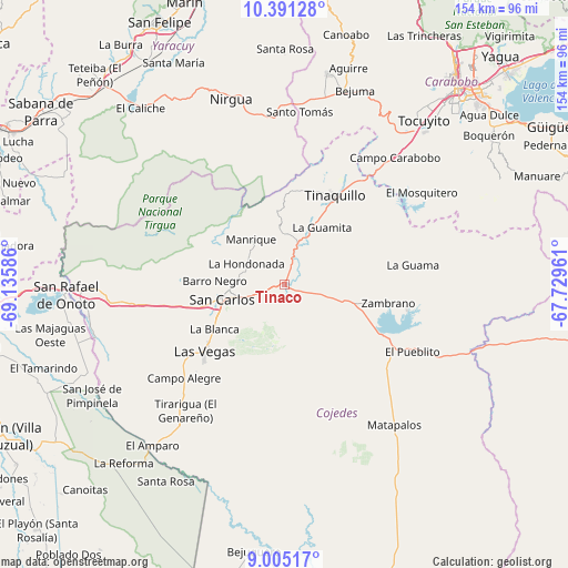
Tinaco GPS coordinates[2]
9° 41' 56.184" North, 68° 25' 57.828" West
| Map corner | latitude | longitude |
|---|---|---|
| Upper-left | 10.39128°, | -69.13586° |
| Center: | 9.69894°, | -68.43273° |
| Lower-right: | 9.00517°, | -67.72961° |
| Map W x H: | 154.1×154.1 km | = 95.8×95.8mi |
| max Lat: | 11.94788° ⇑47.3% North |
| Tinaco: | 9.69894° |
| min Lat: | ⇓52.7% South 1.92027° |
| min Long | Tinaco | max Long |
| -72.55212° | -68.43273° | -60.99778° |
| W 54.2%⇐ | ⇒45.8% E |
Elevation
Elevation of Tinaco is 156 m = 512 ft, and this is 224.6 m = 737 ft below average elevation for this country.
| Max E: |
2986 m = 9797 ft | 56% |
| Avg. | 380.6 m = 1249 ft | |
| Tinaco | 156 m = 512 ft | |
Min E: |
-4 m = -13 ft | 44% |
See also: Venezuela elevation on elevation.city.
Geographical zone
Tinaco is located in North Torrid zone (between Equator and Tropic of Cancer). Distance of Equator is 1078.4 km =670.1 mi to South.| Distance of | km | miles | from Tinaco |
|---|---|---|---|
| North Pole | 8928.6 | 5548 | to North |
| Arctic Circle | 6322.8 | 3928.8 | to North |
| Tropic Cancer | 1527.5 | 949.1 | to North |
| Equator | 1078.4 | 670.1 | to South |


Nearby cities:
15 places around Tinaco: (largest is in red/bold)
• Bejuma
56.1 km =34.9 mi,  19°
19°
• Cojedes
53.9 km =33.5 mi,  260°
260°
• El Pao
33.9 km =21.1 mi,  101°
101°
• Las Vegas
28.1 km =17.5 mi,  230°
230°
• Libertad
47.5 km =29.5 mi,  216°
216°
• Macapo
14.1 km =8.8 mi,  357°
357°
• Miranda
50.4 km =31.3 mi,  4°
4°
• Montalbán
58.3 km =36.2 mi,  11°
11°
• Nirgua
52.2 km =32.4 mi,  343°
343°
• San Carlos
17 km =10.6 mi, 255°
• San Rafael de Onoto
59.2 km =36.8 mi,  267°
267°
• Tacarigua
70.8 km =44 mi,  52°
52°
• Tinaquillo
28.2 km =17.5 mi,  29°
29°
• Tocuyito
61 km =37.9 mi,  40°
40°
• Valencia
69.4 km =43.1 mi, 42°
Sources, notices
• [Note1] Compared only with cities in Venezuela existing in our database
• [Src1] Map data: © OpenStreetMap contributors (CC-BY-SA)
• [Src2] Other city data from geonames.org with taken over terms of usage.
• [Src3] Geographical zone / Annual Mean Temperature by Robert A. Rohde @ Wikipedia
