Coro geodata
Coro (Falcón) is a seat of a first-order administrative division; located in Venezuela in America/Caracas (GMT-4) time zone. With population of 195,227 people, there are 21 cities with bigger population in this country. Compared to other cities in Venezuela, 98.2% of cities are located further ↓South; 60.8% of cities are located further →East and 86.5% of cities have higher elevation than Coro. Note1


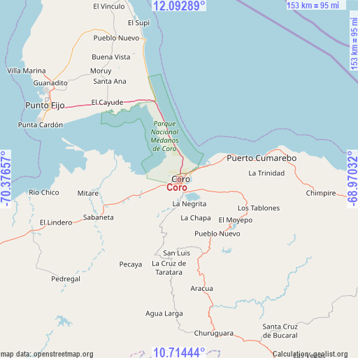
Coro GPS coordinates[2]
11° 24' 16.2" North, 69° 40' 24.384" West
| Map corner | latitude | longitude |
|---|---|---|
| Upper-left | 12.09289°, | -70.37657° |
| Center: | 11.4045°, | -69.67344° |
| Lower-right: | 10.71444°, | -68.97032° |
| Map W x H: | 153.3×153.3 km | = 95.3×95.3mi |
| max Lat: | 11.94788° ⇑1.8% North |
| Coro: | 11.4045° |
| min Lat: | ⇓98.2% South 1.92027° |
| min Long | Coro | max Long |
| -72.55212° | -69.67344° | -60.99778° |
| W 39.2%⇐ | ⇒60.8% E |
Elevation
Elevation of Coro is 27 m = 89 ft, and this is 353.6 m = 1160 ft below average elevation for this country.
| Max E: |
2986 m = 9797 ft | 86.5% |
| Avg. | 380.6 m = 1249 ft | |
| Coro | 27 m = 89 ft | |
Min E: |
-4 m = -13 ft | 13.5% |
See also: Coro elevation on elevation.city.
Geographical zone
Coro is located in North Torrid zone (between Equator and Tropic of Cancer). Distance of Equator is 1268.1 km =788 mi to South.| Distance of | km | miles | from Coro |
|---|---|---|---|
| North Pole | 8739 | 5430.2 | to North |
| Arctic Circle | 6133.1 | 3810.9 | to North |
| Tropic Cancer | 1337.9 | 831.3 | to North |
| Equator | 1268.1 | 788 | to South |


Nearby cities:
15 places around Coro: (largest is in red/bold)
• Cabure
29.6 km =18.4 mi,  166°
166°
• Churuguara
67.5 km =41.9 mi, 167°
• La Cruz de Taratara
38.2 km =23.7 mi,  186°
186°
• La Vela de Coro
13.3 km =8.3 mi,  61°
61°
• Pedregal
64.8 km =40.3 mi,  228°
228°
• Pueblo Nuevo
66.3 km =41.2 mi,  335°
335°
• Puerto Cumarebo
36.1 km =22.4 mi,  75°
75°
• Punta Cardón
65.4 km =40.6 mi,  295°
295°
• Punto Fijo
65.6 km =40.8 mi, 299°
• Píritu
58.5 km =36.4 mi,  94°
94°
• San Luis
31.6 km =19.6 mi,  182°
182°
• Santa Cruz de Bucaral
78.2 km =48.6 mi,  146°
146°
• Santa Cruz de los Taques
78.7 km =48.9 mi,  306°
306°
• Tocópero
46.4 km =28.8 mi, 76°
• Urumaco
67.4 km =41.9 mi,  250°
250°
Sources, notices
• [Note1] Compared only with cities in Venezuela existing in our database
• [Src1] Map data: © OpenStreetMap contributors (CC-BY-SA)
• [Src2] Other city data from geonames.org with taken over terms of usage.
• [Src3] Geographical zone / Annual Mean Temperature by Robert A. Rohde @ Wikipedia
