Cabure geodata
Cabure (Falcón) is a seat of a second-order administrative division; located in Venezuela in America/Caracas (GMT-4) time zone. In our database, there are 108 cities with bigger population. Compared to other cities in Venezuela, 96.7% of cities are located further ↓South; 59.5% of cities are located further →East and 79.4% of cities have lower elevation than Cabure. Note1


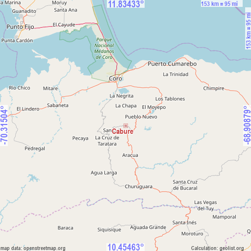
Cabure GPS coordinates[2]
11° 8' 43.08" North, 69° 36' 42.876" West
| Map corner | latitude | longitude |
|---|---|---|
| Upper-left | 11.83433°, | -70.31504° |
| Center: | 11.1453°, | -69.61191° |
| Lower-right: | 10.45463°, | -68.90879° |
| Map W x H: | 153.4×153.4 km | = 95.3×95.3mi |
| max Lat: | 11.94788° ⇑3.3% North |
| Cabure: | 11.1453° |
| min Lat: | ⇓96.7% South 1.92027° |
| min Long | Cabure | max Long |
| -72.55212° | -69.61191° | -60.99778° |
| W 40.5%⇐ | ⇒59.5% E |
Elevation
Elevation of Cabure is 630 m = 2067 ft, and this is 249.4 m = 818 ft above average elevation for this country.
| Max E: |
2986 m = 9797 ft | 20.6% |
| Cabure | 630 m 2067 ft | |
| Avg. | 380.6 m = 1249 ft | |
Min E: |
-4 m = -13 ft | 79.4% |
See also: Venezuela elevation on elevation.city.
Geographical zone
Cabure is located in North Torrid zone (between Equator and Tropic of Cancer). Distance of Equator is 1239.2 km =770 mi to South.| Distance of | km | miles | from Cabure |
|---|---|---|---|
| North Pole | 8767.8 | 5448.1 | to North |
| Arctic Circle | 6161.9 | 3828.8 | to North |
| Tropic Cancer | 1366.7 | 849.2 | to North |
| Equator | 1239.2 | 770 | to South |


Nearby cities:
15 places around Cabure: (largest is in red/bold)
• Churuguara
37.9 km =23.5 mi,  167°
167°
• Coro
29.6 km =18.4 mi,  346°
346°
• Jacura
82.9 km =51.5 mi,  95°
95°
• La Cruz de Taratara
14.3 km =8.9 mi,  230°
230°
• La Vela de Coro
35.4 km =22 mi,  8°
8°
• Pedregal
57.2 km =35.5 mi,  255°
255°
• Puerto Cumarebo
47.2 km =29.3 mi,  36°
36°
• Punta Cardón
87 km =54.1 mi,  310°
310°
• Punto Fijo
88.2 km =54.8 mi, 313°
• Píritu
57.2 km =35.5 mi,  64°
64°
• San Luis
8.3 km =5.2 mi,  250°
250°
• Santa Cruz de Bucaral
51.5 km =32 mi,  134°
134°
• Siquisique
64.6 km =40.1 mi,  188°
188°
• Tocópero
55.1 km =34.2 mi, 44°
• Urumaco
70.5 km =43.8 mi,  275°
275°
Sources, notices
• [Note1] Compared only with cities in Venezuela existing in our database
• [Src1] Map data: © OpenStreetMap contributors (CC-BY-SA)
• [Src2] Other city data from geonames.org with taken over terms of usage.
• [Src3] Geographical zone / Annual Mean Temperature by Robert A. Rohde @ Wikipedia
